Huazhou geodata
Huazhou (Henan) is a seat of a third-order administrative division; located in China in Asia/Shanghai (GMT+8) time zone. With population of 59,338 people, there are 740 cities with bigger population in this country. Compared to other cities in China, 64.7% of cities are located further ↓South; 62.3% of cities are located further →East and 56.7% of cities have higher elevation than Huazhou. Note1


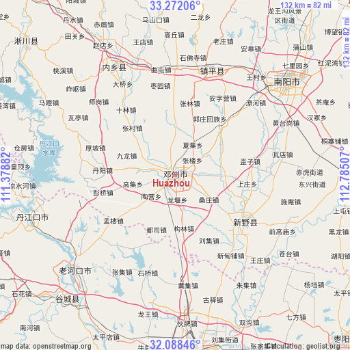
Huazhou GPS coordinates[2]
32° 40' 55.992" North, 112° 4' 54.984" East
| Map corner | latitude | longitude |
|---|---|---|
| Upper-left | 33.27206°, | 111.37882° |
| Center: | 32.68222°, | 112.08194° |
| Lower-right: | 32.08846°, | 112.78507° |
| Map W x H: | 131.6×131.6 km | = 81.8×81.8mi |
| max Lat: | 53.31946° ⇑35.3% North |
| Huazhou: | 32.68222° |
| min Lat: | ⇓64.7% South 18.22056° |
| min Long | Huazhou | max Long |
| 75.07348° | 112.08194° | 134.28917° |
| W 37.7%⇐ | ⇒62.3% E |
Elevation
Elevation of Huazhou is 119 m = 390 ft, and this is 365.8 m = 1200 ft below average elevation for this country.
| Max E: |
5622 m = 18445 ft | 56.7% |
| Avg. | 484.8 m = 1591 ft | |
| Huazhou | 119 m = 390 ft | |
Min E: |
-3 m = -10 ft | 43.3% |
See also: Huazhou elevation on elevation.city.
Geographical zone
Huazhou is located in North temperate zone (between Tropic of Cancer and the Arctic Circle). Distance of this Northern Tropic circle is 1028 km =638.8 mi to South.| Distance of | km | miles | from Huazhou |
|---|---|---|---|
| North Pole | 6373.1 | 3960.1 | to North |
| Arctic Circle | 3767.3 | 2340.9 | to North |
| Tropic Cancer | 1028 | 638.8 | to South |
| Equator | 3633.9 | 2258 | to South |


Nearby cities:
15 places around Huazhou: (largest is in red/bold)
• Chaobei
39.9 km =24.8 mi,  2°
2°
• Chengjiao
43.1 km =26.8 mi,  21°
21°
• Hancheng
31.2 km =19.4 mi,  125°
125°
• Hongshanzui
46.9 km =29.1 mi,  237°
237°
• Huangji
41.5 km =25.8 mi,  173°
173°
• Luyi
46.6 km =29 mi,  356°
356°
• Neixiang Chengguanzhen
46.2 km =28.7 mi,  331°
331°
• Qutun
40.2 km =25 mi,  352°
352°
• Shifosi
44.7 km =27.8 mi,  8°
8°
• Shiqiao
38.1 km =23.7 mi,  195°
195°
• Wanggang
46.6 km =29 mi, 0°
• Yangying
36.5 km =22.7 mi, 12°
• Yuanchong
36.9 km =22.9 mi, 242°
• Zhangji
41.5 km =25.8 mi,  208°
208°
• Zhenping Chengguanzhen
41.5 km =25.8 mi, 19°
Sources, notices
• [Note1] Compared only with cities in China existing in our database
• [Src1] Map data: © OpenStreetMap contributors (CC-BY-SA)
• [Src2] Other city data from geonames.org with taken over terms of usage.
• [Src3] Geographical zone / Annual Mean Temperature by Robert A. Rohde @ Wikipedia
