Hongshanzui geodata
Hongshanzui (Hubei) is a seat of a fourth-order administrative division; located in China in Asia/Shanghai (GMT+8) time zone. In our database, there are 1268 cities with bigger population. Compared to other cities in China, 63.8% of cities are located further ↓South; 64.2% of cities are located further →East and 59.7% of cities have higher elevation than Hongshanzui. Note1


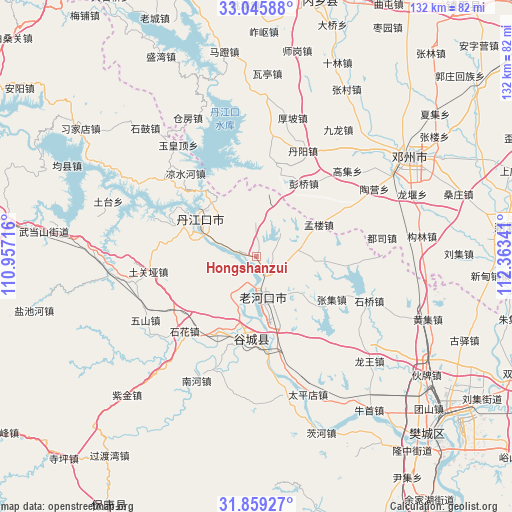
Hongshanzui GPS coordinates[2]
32° 27' 16.308" North, 111° 39' 37.008" East
| Map corner | latitude | longitude |
|---|---|---|
| Upper-left | 33.04588°, | 110.95716° |
| Center: | 32.45453°, | 111.66028° |
| Lower-right: | 31.85927°, | 112.36341° |
| Map W x H: | 131.9×131.9 km | = 82×82mi |
| max Lat: | 53.31946° ⇑36.2% North |
| Hongshanzui: | 32.45453° |
| min Lat: | ⇓63.8% South 18.22056° |
| min Long | Hongshanzui | max Long |
| 75.07348° | 111.66028° | 134.28917° |
| W 35.8%⇐ | ⇒64.2% E |
Elevation
Elevation of Hongshanzui is 100 m = 328 ft, and this is 384.8 m = 1262 ft below average elevation for this country.
| Max E: |
5622 m = 18445 ft | 59.7% |
| Avg. | 484.8 m = 1591 ft | |
| Hongshanzui | 100 m = 328 ft | |
Min E: |
-3 m = -10 ft | 40.3% |
See also: China elevation on elevation.city.
Geographical zone
Hongshanzui is located in North temperate zone (between Tropic of Cancer and the Arctic Circle). Distance of this Northern Tropic circle is 1002.7 km =623 mi to South.| Distance of | km | miles | from Hongshanzui |
|---|---|---|---|
| North Pole | 6398.5 | 3975.8 | to North |
| Arctic Circle | 3792.6 | 2356.6 | to North |
| Tropic Cancer | 1002.7 | 623 | to South |
| Equator | 3608.6 | 2242.3 | to South |


Nearby cities:
15 places around Hongshanzui: (largest is in red/bold)
• Danjiangkou
17.3 km =10.7 mi,  304°
304°
• Danzhaolu
16.6 km =10.3 mi,  311°
311°
• Gucheng Chengguanzhen
21.1 km =13.1 mi,  186°
186°
• Laohekou
7.7 km =4.8 mi,  174°
174°
• Lengji
11.6 km =7.2 mi,  213°
213°
• Liangshuihe
28 km =17.4 mi,  319°
319°
• Nanhe
34.3 km =21.3 mi,  204°
204°
• Sanguandian
17.8 km =11.1 mi,  292°
292°
• Shihua
27.4 km =17 mi,  224°
224°
• Shiqiao
31.7 km =19.7 mi,  111°
111°
• Tuguanya
28 km =17.4 mi,  262°
262°
• Wushan
32.9 km =20.4 mi,  240°
240°
• Xianrendu
22.6 km =14 mi, 167°
• Yuanchong
10.6 km =6.6 mi,  40°
40°
• Zhangji
22.3 km =13.9 mi,  119°
119°
Sources, notices
• [Note1] Compared only with cities in China existing in our database
• [Src1] Map data: © OpenStreetMap contributors (CC-BY-SA)
• [Src2] Other city data from geonames.org with taken over terms of usage.
• [Src3] Geographical zone / Annual Mean Temperature by Robert A. Rohde @ Wikipedia
