Yuanchong geodata
Yuanchong (Hubei) is a seat of a fourth-order administrative division; located in China in Asia/Shanghai (GMT+8) time zone. In our database, there are 1268 cities with bigger population. Compared to other cities in China, 64.1% of cities are located further ↓South; 63.9% of cities are located further →East and 51.3% of cities have lower elevation than Yuanchong. Note1


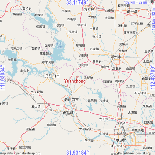
Yuanchong GPS coordinates[2]
32° 31' 35.832" North, 111° 44' 2.256" East
| Map corner | latitude | longitude |
|---|---|---|
| Upper-left | 33.11749°, | 111.03084° |
| Center: | 32.52662°, | 111.73396° |
| Lower-right: | 31.93184°, | 112.43709° |
| Map W x H: | 131.8×131.8 km | = 81.9×81.9mi |
| max Lat: | 53.31946° ⇑35.9% North |
| Yuanchong: | 32.52662° |
| min Lat: | ⇓64.1% South 18.22056° |
| min Long | Yuanchong | max Long |
| 75.07348° | 111.73396° | 134.28917° |
| W 36.1%⇐ | ⇒63.9% E |
Elevation
Elevation of Yuanchong is 175 m = 574 ft, and this is 309.8 m = 1016 ft below average elevation for this country.
| Max E: |
5622 m = 18445 ft | 48.7% |
| Avg. | 484.8 m = 1591 ft | |
| Yuanchong | 175 m = 574 ft | |
Min E: |
-3 m = -10 ft | 51.3% |
See also: China elevation on elevation.city.
Geographical zone
Yuanchong is located in North temperate zone (between Tropic of Cancer and the Arctic Circle). Distance of this Northern Tropic circle is 1010.7 km =628 mi to South.| Distance of | km | miles | from Yuanchong |
|---|---|---|---|
| North Pole | 6390.4 | 3970.8 | to North |
| Arctic Circle | 3784.6 | 2351.6 | to North |
| Tropic Cancer | 1010.7 | 628 | to South |
| Equator | 3616.6 | 2247.3 | to South |


Nearby cities:
15 places around Yuanchong: (largest is in red/bold)
• Danjiangkou
21.2 km =13.2 mi,  274°
274°
• Danzhaolu
19.6 km =12.2 mi,  278°
278°
• Gucheng Chengguanzhen
30.4 km =18.9 mi,  197°
197°
• Hongshanzui
10.6 km =6.6 mi,  220°
220°
• Huazhou
36.9 km =22.9 mi,  62°
62°
• Laohekou
16.8 km =10.4 mi, 201°
• Lengji
22.1 km =13.7 mi, 216°
• Liangshuihe
28.4 km =17.6 mi,  297°
297°
• Sanguandian
23.4 km =14.5 mi, 266°
• Shihua
38 km =23.6 mi, 223°
• Shiqiao
29.8 km =18.5 mi,  130°
130°
• Tuguanya
36.6 km =22.7 mi,  251°
251°
• Xianrendu
30.1 km =18.7 mi,  183°
183°
• Yuhuangding
34 km =21.1 mi,  307°
307°
• Zhangji
22.7 km =14.1 mi,  146°
146°
Sources, notices
• [Note1] Compared only with cities in China existing in our database
• [Src1] Map data: © OpenStreetMap contributors (CC-BY-SA)
• [Src2] Other city data from geonames.org with taken over terms of usage.
• [Src3] Geographical zone / Annual Mean Temperature by Robert A. Rohde @ Wikipedia
