Fengshuling geodata
Fengshuling (Zhejiang) is a seat of a fourth-order administrative division; located in China in Asia/Shanghai (GMT+8) time zone. In our database, there are 1268 cities with bigger population. Compared to other cities in China, 61.1% of cities are located further ↑North; 74.4% of cities are located further ←West and 55.3% of cities have lower elevation than Fengshuling. Note1


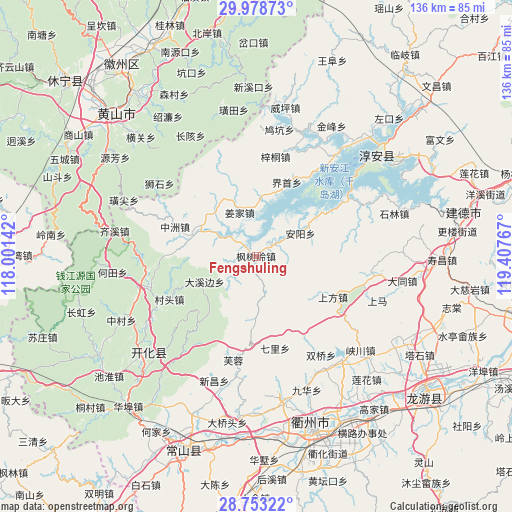
Fengshuling GPS coordinates[2]
29° 22' 4.152" North, 118° 42' 16.344" East
| Map corner | latitude | longitude |
|---|---|---|
| Upper-left | 29.97873°, | 118.00142° |
| Center: | 29.36782°, | 118.70454° |
| Lower-right: | 28.75322°, | 119.40767° |
| Map W x H: | 136.3×136.3 km | = 84.7×84.7mi |
| max Lat: | 53.31946° ⇑61.1% North |
| Fengshuling: | 29.36782° |
| min Lat: | ⇓38.9% South 18.22056° |
| min Long | Fengshuling | max Long |
| 75.07348° | 118.70454° | 134.28917° |
| W 74.4%⇐ | ⇒25.6% E |
Elevation
Elevation of Fengshuling is 209 m = 686 ft, and this is 275.8 m = 905 ft below average elevation for this country.
| Max E: |
5622 m = 18445 ft | 44.7% |
| Avg. | 484.8 m = 1591 ft | |
| Fengshuling | 209 m = 686 ft | |
Min E: |
-3 m = -10 ft | 55.3% |
See also: China elevation on elevation.city.
Geographical zone
Fengshuling is located in North temperate zone (between Tropic of Cancer and the Arctic Circle). Distance of this Northern Tropic circle is 659.5 km =409.8 mi to South.| Distance of | km | miles | from Fengshuling |
|---|---|---|---|
| North Pole | 6741.7 | 4189.1 | to North |
| Arctic Circle | 4135.8 | 2569.9 | to North |
| Tropic Cancer | 659.5 | 409.8 | to South |
| Equator | 3265.4 | 2029 | to South |


Nearby cities:
15 places around Fengshuling: (largest is in red/bold)
• Anyang
13.3 km =8.3 mi,  64°
64°
• Baima
14 km =8.7 mi,  175°
175°
• Dongshan
17.2 km =10.7 mi,  245°
245°
• Dongwu
21.2 km =13.2 mi,  225°
225°
• Guocun
22.2 km =13.8 mi,  341°
341°
• Huanggu
17 km =10.6 mi,  235°
235°
• Huipinggeng
19.6 km =12.2 mi,  132°
132°
• Jiangjia
12.8 km =8 mi, 340°
• Langchuan
18.2 km =11.3 mi,  323°
323°
• Longyuan
12 km =7.5 mi,  288°
288°
• Shangfang
23.2 km =14.4 mi,  118°
118°
• Tangwu
21.9 km =13.6 mi,  263°
263°
• Yangqitan
17.2 km =10.7 mi,  295°
295°
• Yaojia
21.9 km =13.6 mi,  20°
20°
• Zhongzhou
22.9 km =14.2 mi, 290°
Sources, notices
• [Note1] Compared only with cities in China existing in our database
• [Src1] Map data: © OpenStreetMap contributors (CC-BY-SA)
• [Src2] Other city data from geonames.org with taken over terms of usage.
• [Src3] Geographical zone / Annual Mean Temperature by Robert A. Rohde @ Wikipedia
