Dongwu geodata
Dongwu (Zhejiang) is a seat of a fourth-order administrative division; located in China in Asia/Shanghai (GMT+8) time zone. In our database, there are 1268 cities with bigger population. Compared to other cities in China, 62.9% of cities are located further ↑North; 73.5% of cities are located further ←West and 60.6% of cities have lower elevation than Dongwu. Note1


Dongwu GPS coordinates[2]
29° 14' 3.804" North, 118° 32' 51.684" East
| Map corner | latitude | longitude |
|---|---|---|
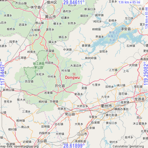
| Upper-left | 29.84611°, | 117.84457° |
| Center: | 29.23439°, | 118.54769° |
| Lower-right: | 28.61899°, | 119.25082° |
| Map W x H: | 136.4×136.4 km | = 84.8×84.8mi |
| max Lat: | 53.31946° ⇑62.9% North |
| Dongwu: | 29.23439° |
| min Lat: | ⇓37.1% South 18.22056° |
| min Long | Dongwu | max Long |
| 75.07348° | 118.54769° | 134.28917° |
| W 73.5%⇐ | ⇒26.5% E |
Elevation
Elevation of Dongwu is 267 m = 876 ft, and this is 217.8 m = 715 ft below average elevation for this country.
| Max E: |
5622 m = 18445 ft | 39.4% |
| Avg. | 484.8 m = 1591 ft | |
| Dongwu | 267 m = 876 ft | |
Min E: |
-3 m = -10 ft | 60.6% |
See also: China elevation on elevation.city.
Geographical zone
Dongwu is located in North temperate zone (between Tropic of Cancer and the Arctic Circle). Distance of this Northern Tropic circle is 644.6 km =400.5 mi to South.| Distance of | km | miles | from Dongwu |
|---|---|---|---|
| North Pole | 6756.5 | 4198.3 | to North |
| Arctic Circle | 4150.6 | 2579.1 | to North |
| Tropic Cancer | 644.6 | 400.5 | to South |
| Equator | 3250.6 | 2019.8 | to South |


Nearby cities:
15 places around Dongwu: (largest is in red/bold)
• Baima
16.4 km =10.2 mi,  86°
86°
• Cuntou
8.4 km =5.2 mi,  293°
293°
• Dongshan
7.6 km =4.7 mi,  356°
356°
• Dongshandi
15.6 km =9.7 mi,  141°
141°
• Furong
15.2 km =9.4 mi,  145°
145°
• Huanggu
5.3 km =3.3 mi,  13°
13°
• Jincun
9.4 km =5.8 mi,  231°
231°
• Kaihua Chengguanzhen
16.7 km =10.4 mi, 233°
• Majin
15.2 km =9.4 mi,  300°
300°
• Shandi
10.7 km =6.6 mi,  275°
275°
• Tangwu
14 km =8.7 mi,  332°
332°
• Xiashan
17.5 km =10.9 mi,  308°
308°
• Xikou
11 km =6.8 mi,  206°
206°
• Xinchang
18.3 km =11.4 mi,  166°
166°
• Yinkeng
15 km =9.3 mi,  254°
254°
Sources, notices
• [Note1] Compared only with cities in China existing in our database
• [Src1] Map data: © OpenStreetMap contributors (CC-BY-SA)
• [Src2] Other city data from geonames.org with taken over terms of usage.
• [Src3] Geographical zone / Annual Mean Temperature by Robert A. Rohde @ Wikipedia
