Xikou geodata
Xikou (Zhejiang) is a seat of a fourth-order administrative division; located in China in Asia/Shanghai (GMT+8) time zone. In our database, there are 1268 cities with bigger population. Compared to other cities in China, 63.8% of cities are located further ↑North; 73.2% of cities are located further ←West and 63.7% of cities have lower elevation than Xikou. Note1


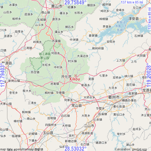
Xikou GPS coordinates[2]
29° 8' 46.464" North, 118° 29' 49.74" East
| Map corner | latitude | longitude |
|---|---|---|
| Upper-left | 29.75849°, | 117.79403° |
| Center: | 29.14624°, | 118.49715° |
| Lower-right: | 28.53032°, | 119.20028° |
| Map W x H: | 136.6×136.6 km | = 84.9×84.9mi |
| max Lat: | 53.31946° ⇑63.8% North |
| Xikou: | 29.14624° |
| min Lat: | ⇓36.2% South 18.22056° |
| min Long | Xikou | max Long |
| 75.07348° | 118.49715° | 134.28917° |
| W 73.2%⇐ | ⇒26.8% E |
Elevation
Elevation of Xikou is 307 m = 1007 ft, and this is 177.8 m = 583 ft below average elevation for this country.
| Max E: |
5622 m = 18445 ft | 36.3% |
| Avg. | 484.8 m = 1591 ft | |
| Xikou | 307 m = 1007 ft | |
Min E: |
-3 m = -10 ft | 63.7% |
See also: China elevation on elevation.city.
Geographical zone
Xikou is located in North temperate zone (between Tropic of Cancer and the Arctic Circle). Distance of this Northern Tropic circle is 634.8 km =394.4 mi to South.| Distance of | km | miles | from Xikou |
|---|---|---|---|
| North Pole | 6766.3 | 4204.4 | to North |
| Arctic Circle | 4160.4 | 2585.2 | to North |
| Tropic Cancer | 634.8 | 394.4 | to South |
| Equator | 3240.8 | 2013.7 | to South |


Nearby cities:
15 places around Xikou: (largest is in red/bold)
• Cuntou
13.5 km =8.4 mi,  347°
347°
• Donglu
14 km =8.7 mi,  164°
164°
• Dongshandi
14.9 km =9.3 mi,  99°
99°
• Dongwu
11 km =6.8 mi,  26°
26°
• Fangcun
15.2 km =9.4 mi,  131°
131°
• Fengjia
16.6 km =10.3 mi,  208°
208°
• Furong
13.9 km =8.6 mi, 101°
• Huanggu
16.2 km =10.1 mi,  22°
22°
• Jincun
4.6 km =2.9 mi,  328°
328°
• Kaihua Chengguanzhen
8.6 km =5.3 mi,  269°
269°
• Qingshandi
12.2 km =7.6 mi,  235°
235°
• Shandi
12.2 km =7.6 mi, 331°
• Wenshan
14.5 km =9 mi,  263°
263°
• Xinchang
12.1 km =7.5 mi, 131°
• Yinkeng
11.2 km =7 mi,  301°
301°
Sources, notices
• [Note1] Compared only with cities in China existing in our database
• [Src1] Map data: © OpenStreetMap contributors (CC-BY-SA)
• [Src2] Other city data from geonames.org with taken over terms of usage.
• [Src3] Geographical zone / Annual Mean Temperature by Robert A. Rohde @ Wikipedia
