Darong geodata
Darong (Guizhou) is a populated place; located in China in Asia/Shanghai (GMT+8) time zone. With population of 1,171 people, there are 1140 cities with bigger population in this country. Compared to other cities in China, 83.2% of cities are located further ↑North; 77% of cities are located further →East and 55.9% of cities have lower elevation than Darong. Note1


Darong GPS coordinates[2]
25° 47' 6" North, 108° 51' 50.4" East
| Map corner | latitude | longitude |
|---|---|---|
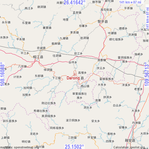
| Upper-left | 26.41642°, | 108.16088° |
| Center: | 25.785°, | 108.864° |
| Lower-right: | 25.1502°, | 109.56713° |
| Map W x H: | 140.8×140.8 km | = 87.5×87.5mi |
| max Lat: | 53.31946° ⇑83.2% North |
| Darong: | 25.785° |
| min Lat: | ⇓16.8% South 18.22056° |
| min Long | Darong | max Long |
| 75.07348° | 108.864° | 134.28917° |
| W 23%⇐ | ⇒77% E |
Elevation
Elevation of Darong is 215 m = 705 ft, and this is 269.8 m = 885 ft below average elevation for this country.
| Max E: |
5622 m = 18445 ft | 44.1% |
| Avg. | 484.8 m = 1591 ft | |
| Darong | 215 m = 705 ft | |
Min E: |
-3 m = -10 ft | 55.9% |
See also: China elevation on elevation.city.
Geographical zone
Darong is located in North temperate zone (between Tropic of Cancer and the Arctic Circle). Distance of this Northern Tropic circle is 261.1 km =162.2 mi to South.| Distance of | km | miles | from Darong |
|---|---|---|---|
| North Pole | 7140 | 4436.6 | to North |
| Arctic Circle | 4534.2 | 2817.4 | to North |
| Tropic Cancer | 261.1 | 162.2 | to South |
| Equator | 2867 | 1781.5 | to South |


Nearby cities:
15 places around Darong: (largest is in red/bold)
• Aoshi
71.6 km =44.5 mi,  16°
16°
• Dingdan
60.2 km =37.4 mi,  277°
277°
• Dundong
37.5 km =23.3 mi,  47°
47°
• Gaowu
25.1 km =15.6 mi,  169°
169°
• Gaozeng
7.6 km =4.7 mi,  75°
75°
• Hongzhou
66.4 km =41.3 mi,  55°
55°
• Pingjiang
20.4 km =12.7 mi, 278°
• Pingjiang
51.2 km =31.8 mi,  293°
293°
• Shuangjiang
21.1 km =13.1 mi, 16°
• Tanxi
67.9 km =42.2 mi,  29°
29°
• Tingdong
25.6 km =15.9 mi, 279°
• Xiajiang
17.5 km =10.9 mi,  259°
259°
• Xishan
14.9 km =9.3 mi,  137°
137°
• Yongcong
39.2 km =24.4 mi,  43°
43°
• Zhongchao
52.9 km =32.9 mi, 42°
Sources, notices
• [Note1] Compared only with cities in China existing in our database
• [Src1] Map data: © OpenStreetMap contributors (CC-BY-SA)
• [Src2] Other city data from geonames.org with taken over terms of usage.
• [Src3] Geographical zone / Annual Mean Temperature by Robert A. Rohde @ Wikipedia
