Shuangjiang geodata
Shuangjiang (Guizhou) is a populated place; located in China in Asia/Shanghai (GMT+8) time zone. With population of 814 people, there are 1215 cities with bigger population in this country. Compared to other cities in China, 82.5% of cities are located further ↑North; 76.7% of cities are located further →East and 58.6% of cities have lower elevation than Shuangjiang. Note1


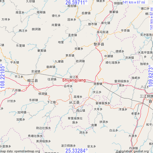
Shuangjiang GPS coordinates[2]
25° 58' 0.012" North, 108° 55' 27.012" East
| Map corner | latitude | longitude |
|---|---|---|
| Upper-left | 26.59711°, | 108.22105° |
| Center: | 25.96667°, | 108.92417° |
| Lower-right: | 25.33284°, | 109.6273° |
| Map W x H: | 140.6×140.6 km | = 87.4×87.4mi |
| max Lat: | 53.31946° ⇑82.5% North |
| Shuangjiang: | 25.96667° |
| min Lat: | ⇓17.5% South 18.22056° |
| min Long | Shuangjiang | max Long |
| 75.07348° | 108.92417° | 134.28917° |
| W 23.3%⇐ | ⇒76.7% E |
Elevation
Elevation of Shuangjiang is 242 m = 794 ft, and this is 242.8 m = 797 ft below average elevation for this country.
| Max E: |
5622 m = 18445 ft | 41.4% |
| Avg. | 484.8 m = 1591 ft | |
| Shuangjiang | 242 m = 794 ft | |
Min E: |
-3 m = -10 ft | 58.6% |
See also: China elevation on elevation.city.
Geographical zone
Shuangjiang is located in North temperate zone (between Tropic of Cancer and the Arctic Circle). Distance of this Northern Tropic circle is 281.3 km =174.8 mi to South.| Distance of | km | miles | from Shuangjiang |
|---|---|---|---|
| North Pole | 7119.8 | 4424 | to North |
| Arctic Circle | 4514 | 2804.9 | to North |
| Tropic Cancer | 281.3 | 174.8 | to South |
| Equator | 2887.2 | 1794 | to South |


Nearby cities:
15 places around Shuangjiang: (largest is in red/bold)
• Aoshi
50.5 km =31.4 mi,  16°
16°
• Darong
21.1 km =13.1 mi,  196°
196°
• Dundong
22.2 km =13.8 mi,  76°
76°
• Gaowu
45 km =28 mi,  182°
182°
• Gaozeng
18.4 km =11.4 mi, 175°
• Hongzhou
51.6 km =32.1 mi,  69°
69°
• Longlisuo
52.8 km =32.8 mi, 19°
• Pingjiang
31.4 km =19.5 mi,  236°
236°
• Pingjiang
52.9 km =32.9 mi,  270°
270°
• Tanxi
47.6 km =29.6 mi,  35°
35°
• Tingdong
35 km =21.7 mi, 243°
• Xiajiang
33 km =20.5 mi,  224°
224°
• Xishan
31.5 km =19.6 mi,  172°
172°
• Yongcong
22.3 km =13.9 mi, 67°
• Zhongchao
35.1 km =21.8 mi,  57°
57°
Sources, notices
• [Note1] Compared only with cities in China existing in our database
• [Src1] Map data: © OpenStreetMap contributors (CC-BY-SA)
• [Src2] Other city data from geonames.org with taken over terms of usage.
• [Src3] Geographical zone / Annual Mean Temperature by Robert A. Rohde @ Wikipedia
