Dajing geodata
Dajing (Guangdong) is a seat of a fourth-order administrative division; located in China in Asia/Urumqi (GMT+6) time zone. In our database, there are 1268 cities with bigger population. Compared to other cities in China, 97.1% of cities are located further ↑North; 67.6% of cities are located further →East and 70.8% of cities have higher elevation than Dajing. Note1


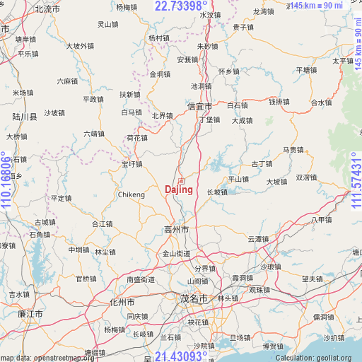
Dajing GPS coordinates[2]
22° 5' 2.256" North, 110° 52' 16.248" East
| Map corner | latitude | longitude |
|---|---|---|
| Upper-left | 22.73398°, | 110.16806° |
| Center: | 22.08396°, | 110.87118° |
| Lower-right: | 21.43093°, | 111.57431° |
| Map W x H: | 144.9×144.9 km | = 90×90mi |
| max Lat: | 53.31946° ⇑97.1% North |
| Dajing: | 22.08396° |
| min Lat: | ⇓2.9% South 18.22056° |
| min Long | Dajing | max Long |
| 75.07348° | 110.87118° | 134.28917° |
| W 32.4%⇐ | ⇒67.6% E |
Elevation
Elevation of Dajing is 49 m = 161 ft, and this is 435.8 m = 1430 ft below average elevation for this country.
| Max E: |
5622 m = 18445 ft | 70.8% |
| Avg. | 484.8 m = 1591 ft | |
| Dajing | 49 m = 161 ft | |
Min E: |
-3 m = -10 ft | 29.2% |
See also: China elevation on elevation.city.
Geographical zone
Dajing is located in North Torrid zone (between Equator and Tropic of Cancer). Distance of this Northern Tropic circle is 150.4 km =93.5 mi to North.| Distance of | km | miles | from Dajing |
|---|---|---|---|
| North Pole | 7551.6 | 4692.3 | to North |
| Arctic Circle | 4945.7 | 3073.1 | to North |
| Tropic Cancer | 150.4 | 93.5 | to North |
| Equator | 2455.5 | 1525.8 | to South |


Nearby cities:
15 places around Dajing: (largest is in red/bold)
• Baoguang
17.6 km =10.9 mi,  190°
190°
• Baoxu
21.2 km =13.2 mi,  289°
289°
• Caojiang
13.4 km =8.3 mi,  145°
145°
• Changpo
15.1 km =9.4 mi,  98°
98°
• Dong’an
9.7 km =6 mi,  58°
58°
• Gaozhou
16.3 km =10.1 mi, 189°
• Hetang
18.3 km =11.4 mi,  243°
243°
• Nantang
8.8 km =5.5 mi,  253°
253°
• Panzhou
17.7 km =11 mi, 187°
• Shanmei
17 km =10.6 mi,  179°
179°
• Shiban
17.9 km =11.1 mi,  295°
295°
• Shuikou
19 km =11.8 mi,  13°
13°
• Tantou
11.2 km =7 mi,  352°
352°
• Xieji
21.9 km =13.6 mi, 148°
• Zhenlong
14.2 km =8.8 mi,  1°
1°
Sources, notices
• [Note1] Compared only with cities in China existing in our database
• [Src1] Map data: © OpenStreetMap contributors (CC-BY-SA)
• [Src2] Other city data from geonames.org with taken over terms of usage.
• [Src3] Geographical zone / Annual Mean Temperature by Robert A. Rohde @ Wikipedia
