Zhenlong geodata
Zhenlong (Guangdong) is a seat of a fourth-order administrative division; located in China in Asia/Urumqi (GMT+6) time zone. In our database, there are 1268 cities with bigger population. Compared to other cities in China, 96.9% of cities are located further ↑North; 67.5% of cities are located further →East and 66.8% of cities have higher elevation than Zhenlong. Note1


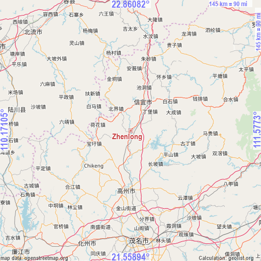
Zhenlong GPS coordinates[2]
22° 12' 41.004" North, 110° 52' 27.012" East
| Map corner | latitude | longitude |
|---|---|---|
| Upper-left | 22.86082°, | 110.17105° |
| Center: | 22.21139°, | 110.87417° |
| Lower-right: | 21.55894°, | 111.5773° |
| Map W x H: | 144.8×144.8 km | = 90×90mi |
| max Lat: | 53.31946° ⇑96.9% North |
| Zhenlong: | 22.21139° |
| min Lat: | ⇓3.1% South 18.22056° |
| min Long | Zhenlong | max Long |
| 75.07348° | 110.87417° | 134.28917° |
| W 32.5%⇐ | ⇒67.5% E |
Elevation
Elevation of Zhenlong is 65 m = 213 ft, and this is 419.8 m = 1377 ft below average elevation for this country.
| Max E: |
5622 m = 18445 ft | 66.8% |
| Avg. | 484.8 m = 1591 ft | |
| Zhenlong | 65 m = 213 ft | |
Min E: |
-3 m = -10 ft | 33.2% |
See also: China elevation on elevation.city.
Geographical zone
Zhenlong is located in North Torrid zone (between Equator and Tropic of Cancer). Distance of this Northern Tropic circle is 136.2 km =84.6 mi to North.| Distance of | km | miles | from Zhenlong |
|---|---|---|---|
| North Pole | 7537.4 | 4683.5 | to North |
| Arctic Circle | 4931.5 | 3064.3 | to North |
| Tropic Cancer | 136.2 | 84.6 | to North |
| Equator | 2469.7 | 1534.6 | to South |


Nearby cities:
15 places around Zhenlong: (largest is in red/bold)
• Baoxu
21.4 km =13.3 mi,  250°
250°
• Beijie
14.3 km =8.9 mi,  327°
327°
• Changpo
22 km =13.7 mi,  138°
138°
• Chidong
25.2 km =15.7 mi,  17°
17°
• Dajing
14.2 km =8.8 mi,  181°
181°
• Dingbao
14.4 km =8.9 mi,  45°
45°
• Dongzhen
19.9 km =12.4 mi, 19°
• Dong’an
12 km =7.5 mi, 138°
• Hehua
18.1 km =11.2 mi,  280°
280°
• Nantang
18.8 km =11.7 mi,  207°
207°
• Shenzhen
25.3 km =15.7 mi,  97°
97°
• Shiban
17.6 km =10.9 mi, 248°
• Shuikou
5.9 km =3.7 mi,  43°
43°
• Tantou
3.5 km =2.2 mi, 210°
• Xinyi
19.5 km =12.1 mi, 22°
Sources, notices
• [Note1] Compared only with cities in China existing in our database
• [Src1] Map data: © OpenStreetMap contributors (CC-BY-SA)
• [Src2] Other city data from geonames.org with taken over terms of usage.
• [Src3] Geographical zone / Annual Mean Temperature by Robert A. Rohde @ Wikipedia
