Tantou geodata
Tantou (Guangdong) is a seat of a fourth-order administrative division; located in China in Asia/Urumqi (GMT+6) time zone. In our database, there are 1268 cities with bigger population. Compared to other cities in China, 97% of cities are located further ↑North; 67.6% of cities are located further →East and 66.1% of cities have higher elevation than Tantou. Note1


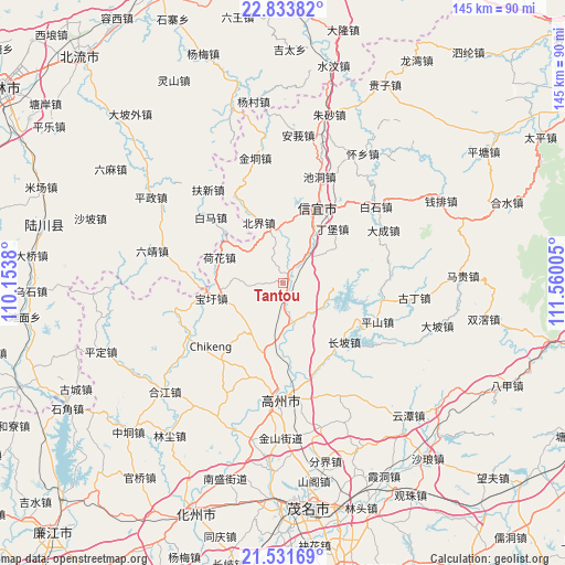
Tantou GPS coordinates[2]
22° 11' 3.336" North, 110° 51' 24.912" East
| Map corner | latitude | longitude |
|---|---|---|
| Upper-left | 22.83382°, | 110.1538° |
| Center: | 22.18426°, | 110.85692° |
| Lower-right: | 21.53169°, | 111.56005° |
| Map W x H: | 144.8×144.8 km | = 90×90mi |
| max Lat: | 53.31946° ⇑97% North |
| Tantou: | 22.18426° |
| min Lat: | ⇓3% South 18.22056° |
| min Long | Tantou | max Long |
| 75.07348° | 110.85692° | 134.28917° |
| W 32.4%⇐ | ⇒67.6% E |
Elevation
Elevation of Tantou is 68 m = 223 ft, and this is 416.8 m = 1367 ft below average elevation for this country.
| Max E: |
5622 m = 18445 ft | 66.1% |
| Avg. | 484.8 m = 1591 ft | |
| Tantou | 68 m = 223 ft | |
Min E: |
-3 m = -10 ft | 33.9% |
See also: China elevation on elevation.city.
Geographical zone
Tantou is located in North Torrid zone (between Equator and Tropic of Cancer). Distance of this Northern Tropic circle is 139.3 km =86.6 mi to North.| Distance of | km | miles | from Tantou |
|---|---|---|---|
| North Pole | 7540.4 | 4685.4 | to North |
| Arctic Circle | 4934.5 | 3066.2 | to North |
| Tropic Cancer | 139.3 | 86.6 | to North |
| Equator | 2466.7 | 1532.7 | to South |


Nearby cities:
15 places around Tantou: (largest is in red/bold)
• Baoxu
18.8 km =11.7 mi,  257°
257°
• Beijie
16.1 km =10 mi,  338°
338°
• Caojiang
23.9 km =14.9 mi,  157°
157°
• Changpo
21.2 km =13.2 mi,  129°
129°
• Dajing
11.2 km =7 mi,  172°
172°
• Dingbao
17.8 km =11.1 mi,  42°
42°
• Dongzhen
23.3 km =14.5 mi,  21°
21°
• Dong’an
11.4 km =7.1 mi,  122°
122°
• Hehua
17.3 km =10.7 mi,  291°
291°
• Hetang
24.4 km =15.2 mi,  217°
217°
• Nantang
15.3 km =9.5 mi,  207°
207°
• Shiban
15 km =9.3 mi, 256°
• Shuikou
9.4 km =5.8 mi, 38°
• Xinyi
23 km =14.3 mi, 23°
• Zhenlong
3.5 km =2.2 mi,  30°
30°
Sources, notices
• [Note1] Compared only with cities in China existing in our database
• [Src1] Map data: © OpenStreetMap contributors (CC-BY-SA)
• [Src2] Other city data from geonames.org with taken over terms of usage.
• [Src3] Geographical zone / Annual Mean Temperature by Robert A. Rohde @ Wikipedia
