Dachen geodata
Dachen (Zhejiang) is a seat of a fourth-order administrative division; located in China in Asia/Shanghai (GMT+8) time zone. In our database, there are 1268 cities with bigger population. Compared to other cities in China, 60.3% of cities are located further ↑North; 82.7% of cities are located further ←West and 66.1% of cities have higher elevation than Dachen. Note1


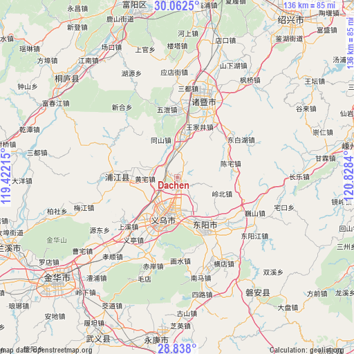
Dachen GPS coordinates[2]
29° 27' 7.56" North, 120° 7' 30.972" East
| Map corner | latitude | longitude |
|---|---|---|
| Upper-left | 30.0625°, | 119.42215° |
| Center: | 29.4521°, | 120.12527° |
| Lower-right: | 28.838°, | 120.8284° |
| Map W x H: | 136.2×136.2 km | = 84.6×84.6mi |
| max Lat: | 53.31946° ⇑60.3% North |
| Dachen: | 29.4521° |
| min Lat: | ⇓39.7% South 18.22056° |
| min Long | Dachen | max Long |
| 75.07348° | 120.12527° | 134.28917° |
| W 82.7%⇐ | ⇒17.3% E |
Elevation
Elevation of Dachen is 68 m = 223 ft, and this is 416.8 m = 1367 ft below average elevation for this country.
| Max E: |
5622 m = 18445 ft | 66.1% |
| Avg. | 484.8 m = 1591 ft | |
| Dachen | 68 m = 223 ft | |
Min E: |
-3 m = -10 ft | 33.9% |
See also: China elevation on elevation.city.
Geographical zone
Dachen is located in North temperate zone (between Tropic of Cancer and the Arctic Circle). Distance of this Northern Tropic circle is 668.8 km =415.6 mi to South.| Distance of | km | miles | from Dachen |
|---|---|---|---|
| North Pole | 6732.3 | 4183.3 | to North |
| Arctic Circle | 4126.4 | 2564 | to North |
| Tropic Cancer | 668.8 | 415.6 | to South |
| Equator | 3274.8 | 2034.9 | to South |


Nearby cities:
15 places around Dachen: (largest is in red/bold)
• Anhua
11.9 km =7.4 mi,  354°
354°
• Chenzhai
21.1 km =13.1 mi,  76°
76°
• Choujiang
21 km =13 mi,  206°
206°
• Dongyang
22.7 km =14.1 mi,  154°
154°
• Gaochengtou
15.8 km =9.8 mi,  336°
336°
• Huangshan
23.5 km =14.6 mi,  55°
55°
• Huangzhai
12.6 km =7.8 mi,  268°
268°
• Jiangbei
19.8 km =12.3 mi, 148°
• Lingbeizhou
18.4 km =11.4 mi,  109°
109°
• Paitou
17.3 km =10.7 mi,  8°
8°
• Puyang
22.9 km =14.2 mi, 271°
• Wangjiajing
21.4 km =13.3 mi,  23°
23°
• Wuning
23.8 km =14.8 mi, 154°
• Yantou
17 km =10.6 mi,  284°
284°
• Yiwu
15.9 km =9.9 mi,  197°
197°
Sources, notices
• [Note1] Compared only with cities in China existing in our database
• [Src1] Map data: © OpenStreetMap contributors (CC-BY-SA)
• [Src2] Other city data from geonames.org with taken over terms of usage.
• [Src3] Geographical zone / Annual Mean Temperature by Robert A. Rohde @ Wikipedia
