Huangzhai geodata
Huangzhai (Zhejiang) is a seat of a fourth-order administrative division; located in China in Asia/Shanghai (GMT+8) time zone. In our database, there are 1268 cities with bigger population. Compared to other cities in China, 60.3% of cities are located further ↑North; 81.9% of cities are located further ←West and 70.3% of cities have higher elevation than Huangzhai. Note1


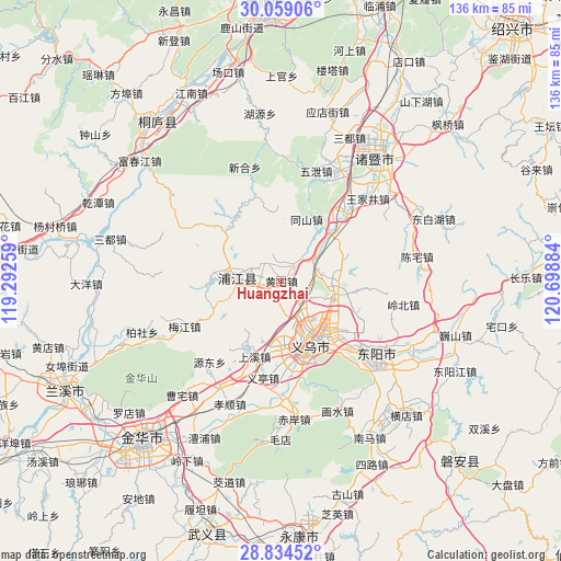
Huangzhai GPS coordinates[2]
29° 26' 55.104" North, 119° 59' 44.556" East
| Map corner | latitude | longitude |
|---|---|---|
| Upper-left | 30.05906°, | 119.29259° |
| Center: | 29.44864°, | 119.99571° |
| Lower-right: | 28.83452°, | 120.69884° |
| Map W x H: | 136.2×136.2 km | = 84.6×84.6mi |
| max Lat: | 53.31946° ⇑60.3% North |
| Huangzhai: | 29.44864° |
| min Lat: | ⇓39.7% South 18.22056° |
| min Long | Huangzhai | max Long |
| 75.07348° | 119.99571° | 134.28917° |
| W 81.9%⇐ | ⇒18.1% E |
Elevation
Elevation of Huangzhai is 51 m = 167 ft, and this is 433.8 m = 1423 ft below average elevation for this country.
| Max E: |
5622 m = 18445 ft | 70.3% |
| Avg. | 484.8 m = 1591 ft | |
| Huangzhai | 51 m = 167 ft | |
Min E: |
-3 m = -10 ft | 29.7% |
See also: China elevation on elevation.city.
Geographical zone
Huangzhai is located in North temperate zone (between Tropic of Cancer and the Arctic Circle). Distance of this Northern Tropic circle is 668.5 km =415.4 mi to South.| Distance of | km | miles | from Huangzhai |
|---|---|---|---|
| North Pole | 6732.7 | 4183.5 | to North |
| Arctic Circle | 4126.8 | 2564.3 | to North |
| Tropic Cancer | 668.5 | 415.4 | to South |
| Equator | 3274.4 | 2034.6 | to South |


Nearby cities:
15 places around Huangzhai: (largest is in red/bold)
• Anhua
16.7 km =10.4 mi,  43°
43°
• Choujiang
18.6 km =11.6 mi,  170°
170°
• Dachen
12.6 km =7.8 mi,  88°
88°
• Duntou
25.8 km =16 mi,  245°
245°
• Fucun
25.2 km =15.7 mi,  203°
203°
• Gaochengtou
16.2 km =10.1 mi,  23°
23°
• Meijiang
20.2 km =12.6 mi,  243°
243°
• Paitou
23.1 km =14.4 mi, 40°
• Puyang
10.4 km =6.5 mi,  274°
274°
• Shangxi
19.2 km =11.9 mi, 198°
• Tanxi
20.6 km =12.8 mi,  345°
345°
• Yantou
6.1 km =3.8 mi,  319°
319°
• Yiting
23.9 km =14.9 mi,  188°
188°
• Yiwu
16.8 km =10.4 mi,  152°
152°
• Yuzhai
18 km =11.2 mi, 316°
Sources, notices
• [Note1] Compared only with cities in China existing in our database
• [Src1] Map data: © OpenStreetMap contributors (CC-BY-SA)
• [Src2] Other city data from geonames.org with taken over terms of usage.
• [Src3] Geographical zone / Annual Mean Temperature by Robert A. Rohde @ Wikipedia
