Choujiang geodata
Choujiang (Zhejiang) is a seat of a fourth-order administrative division; located in China in Asia/Shanghai (GMT+8) time zone. In our database, there are 1268 cities with bigger population. Compared to other cities in China, 62.2% of cities are located further ↑North; 82.1% of cities are located further ←West and 63.5% of cities have higher elevation than Choujiang. Note1


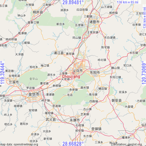
Choujiang GPS coordinates[2]
29° 17' 0.204" North, 120° 1' 39.216" East
| Map corner | latitude | longitude |
|---|---|---|
| Upper-left | 29.89481°, | 119.32444° |
| Center: | 29.28339°, | 120.02756° |
| Lower-right: | 28.66828°, | 120.73069° |
| Map W x H: | 136.4×136.4 km | = 84.8×84.8mi |
| max Lat: | 53.31946° ⇑62.2% North |
| Choujiang: | 29.28339° |
| min Lat: | ⇓37.8% South 18.22056° |
| min Long | Choujiang | max Long |
| 75.07348° | 120.02756° | 134.28917° |
| W 82.1%⇐ | ⇒17.9% E |
Elevation
Elevation of Choujiang is 80 m = 262 ft, and this is 404.8 m = 1328 ft below average elevation for this country.
| Max E: |
5622 m = 18445 ft | 63.5% |
| Avg. | 484.8 m = 1591 ft | |
| Choujiang | 80 m = 262 ft | |
Min E: |
-3 m = -10 ft | 36.5% |
See also: China elevation on elevation.city.
Geographical zone
Choujiang is located in North temperate zone (between Tropic of Cancer and the Arctic Circle). Distance of this Northern Tropic circle is 650.1 km =404 mi to South.| Distance of | km | miles | from Choujiang |
|---|---|---|---|
| North Pole | 6751.1 | 4194.9 | to North |
| Arctic Circle | 4145.2 | 2575.7 | to North |
| Tropic Cancer | 650.1 | 404 | to South |
| Equator | 3256 | 2023.2 | to South |


Nearby cities:
15 places around Choujiang: (largest is in red/bold)
• Chi’an
15.4 km =9.6 mi,  178°
178°
• Dachen
21 km =13 mi,  26°
26°
• Dongyang
19.3 km =12 mi,  95°
95°
• Fucun
13.9 km =8.6 mi,  249°
249°
• Huangtianfan
16.6 km =10.3 mi,  140°
140°
• Huangzhai
18.6 km =11.6 mi,  350°
350°
• Huaxi
16.1 km =10 mi,  127°
127°
• Jiangbei
19.9 km =12.4 mi,  84°
84°
• Maodian
20.5 km =12.7 mi,  189°
189°
• Meijiang
23.1 km =14.4 mi,  293°
293°
• Shangxi
9.3 km =5.8 mi,  271°
271°
• Wuning
19.9 km =12.4 mi, 97°
• Xiaoshun
19.1 km =11.9 mi,  233°
233°
• Yiting
8.3 km =5.2 mi, 230°
• Yiwu
5.9 km =3.7 mi,  53°
53°
Sources, notices
• [Note1] Compared only with cities in China existing in our database
• [Src1] Map data: © OpenStreetMap contributors (CC-BY-SA)
• [Src2] Other city data from geonames.org with taken over terms of usage.
• [Src3] Geographical zone / Annual Mean Temperature by Robert A. Rohde @ Wikipedia
