Dachang geodata
Dachang (Chongqing) is a seat of a fourth-order administrative division; located in China in Asia/Shanghai (GMT+8) time zone. In our database, there are 1268 cities with bigger population. Compared to other cities in China, 56.8% of cities are located further ↓South; 72.3% of cities are located further →East and 51.8% of cities have higher elevation than Dachang. Note1


Dachang GPS coordinates[2]
31° 16' 6.996" North, 109° 48' 7.56" East
| Map corner | latitude | longitude |
|---|---|---|
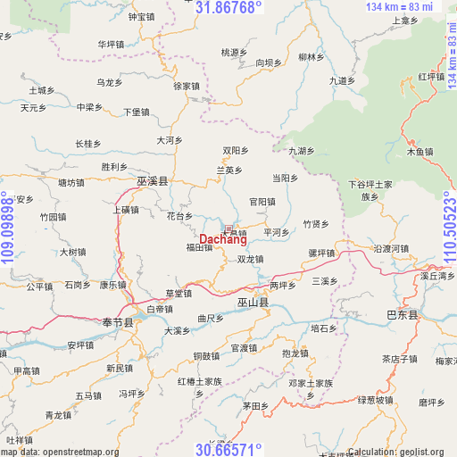
| Upper-left | 31.86768°, | 109.09898° |
| Center: | 31.26861°, | 109.8021° |
| Lower-right: | 30.66571°, | 110.50523° |
| Map W x H: | 133.6×133.6 km | = 83×83mi |
| max Lat: | 53.31946° ⇑43.2% North |
| Dachang: | 31.26861° |
| min Lat: | ⇓56.8% South 18.22056° |
| min Long | Dachang | max Long |
| 75.07348° | 109.8021° | 134.28917° |
| W 27.7%⇐ | ⇒72.3% E |
Elevation
Elevation of Dachang is 151 m = 495 ft, and this is 333.8 m = 1095 ft below average elevation for this country.
| Max E: |
5622 m = 18445 ft | 51.8% |
| Avg. | 484.8 m = 1591 ft | |
| Dachang | 151 m = 495 ft | |
Min E: |
-3 m = -10 ft | 48.2% |
See also: China elevation on elevation.city.
Geographical zone
Dachang is located in North temperate zone (between Tropic of Cancer and the Arctic Circle). Distance of this Northern Tropic circle is 870.8 km =541.1 mi to South.| Distance of | km | miles | from Dachang |
|---|---|---|---|
| North Pole | 6530.3 | 4057.7 | to North |
| Arctic Circle | 3924.4 | 2438.5 | to North |
| Tropic Cancer | 870.8 | 541.1 | to South |
| Equator | 3476.7 | 2160.3 | to South |


Nearby cities:
15 places around Dachang: (largest is in red/bold)
• Chengxiang
22.3 km =13.9 mi,  310°
310°
• Dangyang
22.6 km =14 mi,  47°
47°
• Futian
10.1 km =6.3 mi,  239°
239°
• Guanyang
12.8 km =8 mi, 50°
• Huatai
14.9 km =9.3 mi,  285°
285°
• Jinping
14.3 km =8.9 mi,  117°
117°
• Liangping
22.8 km =14.2 mi,  135°
135°
• Longjing
21.5 km =13.4 mi,  157°
157°
• Longxi
16.3 km =10.1 mi,  283°
283°
• Pinghe
13.9 km =8.6 mi,  93°
93°
• Pulian
23.2 km =14.4 mi, 278°
• Shuanglong
11.1 km =6.9 mi, 137°
• Shuangyang
23.2 km =14.4 mi,  4°
4°
• Tongcheng
15.7 km =9.8 mi,  336°
336°
• Wushan
22.1 km =13.7 mi, 161°
Sources, notices
• [Note1] Compared only with cities in China existing in our database
• [Src1] Map data: © OpenStreetMap contributors (CC-BY-SA)
• [Src2] Other city data from geonames.org with taken over terms of usage.
• [Src3] Geographical zone / Annual Mean Temperature by Robert A. Rohde @ Wikipedia
