Liangping geodata
Liangping (Chongqing) is a seat of a fourth-order administrative division; located in China in Asia/Shanghai (GMT+8) time zone. In our database, there are 1268 cities with bigger population. Compared to other cities in China, 55.7% of cities are located further ↓South; 71.4% of cities are located further →East and 83.5% of cities have lower elevation than Liangping. Note1


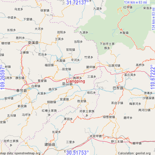
Liangping GPS coordinates[2]
31° 7' 16.896" North, 109° 58' 8.724" East
| Map corner | latitude | longitude |
|---|---|---|
| Upper-left | 31.72137°, | 109.26597° |
| Center: | 31.12136°, | 109.96909° |
| Lower-right: | 30.51753°, | 110.67222° |
| Map W x H: | 133.9×133.9 km | = 83.2×83.2mi |
| max Lat: | 53.31946° ⇑44.3% North |
| Liangping: | 31.12136° |
| min Lat: | ⇓55.7% South 18.22056° |
| min Long | Liangping | max Long |
| 75.07348° | 109.96909° | 134.28917° |
| W 28.6%⇐ | ⇒71.4% E |
Elevation
Elevation of Liangping is 886 m = 2907 ft, and this is 401.2 m = 1316 ft above average elevation for this country.
| Max E: |
5622 m = 18445 ft | 16.5% |
| Liangping | 886 m 2907 ft | |
| Avg. | 484.8 m = 1591 ft | |
Min E: |
-3 m = -10 ft | 83.5% |
See also: China elevation on elevation.city.
Geographical zone
Liangping is located in North temperate zone (between Tropic of Cancer and the Arctic Circle). Distance of this Northern Tropic circle is 854.5 km =531 mi to South.| Distance of | km | miles | from Liangping |
|---|---|---|---|
| North Pole | 6546.7 | 4067.9 | to North |
| Arctic Circle | 3940.8 | 2448.7 | to North |
| Tropic Cancer | 854.5 | 531 | to South |
| Equator | 3460.4 | 2150.2 | to South |


Nearby cities:
15 places around Liangping: (largest is in red/bold)
• Baolong
20.2 km =12.6 mi,  170°
170°
• Dachang
22.8 km =14.2 mi,  315°
315°
• Duping
24.8 km =15.4 mi,  148°
148°
• Guandu
21.8 km =13.5 mi,  212°
212°
• Guanyang
25.3 km =15.7 mi,  346°
346°
• Jianping
9.5 km =5.9 mi, 206°
• Jinping
10.2 km =6.3 mi,  341°
341°
• Longjing
8.6 km =5.3 mi,  245°
245°
• Luoping
14.7 km =9.1 mi,  49°
49°
• Pinghe
15.5 km =9.6 mi, 352°
• Quchi
23 km =14.3 mi, 245°
• Sanxi
12 km =7.5 mi,  84°
84°
• Shuanglong
11.7 km =7.3 mi,  314°
314°
• Wushan
10 km =6.2 mi,  242°
242°
• Zhuxian
20.4 km =12.7 mi,  28°
28°
Sources, notices
• [Note1] Compared only with cities in China existing in our database
• [Src1] Map data: © OpenStreetMap contributors (CC-BY-SA)
• [Src2] Other city data from geonames.org with taken over terms of usage.
• [Src3] Geographical zone / Annual Mean Temperature by Robert A. Rohde @ Wikipedia
