Guanyang geodata
Guanyang (Chongqing) is a seat of a fourth-order administrative division; located in China in Asia/Shanghai (GMT+8) time zone. In our database, there are 1268 cities with bigger population. Compared to other cities in China, 57.4% of cities are located further ↓South; 71.7% of cities are located further →East and 89.1% of cities have lower elevation than Guanyang. Note1


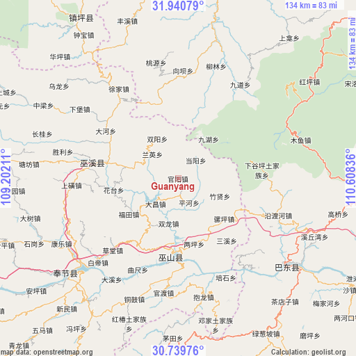
Guanyang GPS coordinates[2]
31° 20' 31.884" North, 109° 54' 18.828" East
| Map corner | latitude | longitude |
|---|---|---|
| Upper-left | 31.94079°, | 109.20211° |
| Center: | 31.34219°, | 109.90523° |
| Lower-right: | 30.73976°, | 110.60836° |
| Map W x H: | 133.5×133.5 km | = 83×83mi |
| max Lat: | 53.31946° ⇑42.6% North |
| Guanyang: | 31.34219° |
| min Lat: | ⇓57.4% South 18.22056° |
| min Long | Guanyang | max Long |
| 75.07348° | 109.90523° | 134.28917° |
| W 28.3%⇐ | ⇒71.7% E |
Elevation
Elevation of Guanyang is 1281 m = 4203 ft, and this is 796.2 m = 2612 ft above average elevation for this country.
| Max E: |
5622 m = 18445 ft | 10.9% |
| Guanyang | 1281 m 4203 ft | |
| Avg. | 484.8 m = 1591 ft | |
Min E: |
-3 m = -10 ft | 89.1% |
See also: China elevation on elevation.city.
Geographical zone
Guanyang is located in North temperate zone (between Tropic of Cancer and the Arctic Circle). Distance of this Northern Tropic circle is 879 km =546.2 mi to South.| Distance of | km | miles | from Guanyang |
|---|---|---|---|
| North Pole | 6522.1 | 4052.6 | to North |
| Arctic Circle | 3916.2 | 2433.4 | to North |
| Tropic Cancer | 879 | 546.2 | to South |
| Equator | 3484.9 | 2165.4 | to South |


Nearby cities:
15 places around Guanyang: (largest is in red/bold)
• Dachang
12.8 km =8 mi,  230°
230°
• Dangyang
9.9 km =6.2 mi,  44°
44°
• Futian
22.8 km =14.2 mi, 234°
• Huatai
24.4 km =15.2 mi,  260°
260°
• Jinping
15.1 km =9.4 mi,  169°
169°
• Jiuhu
22.8 km =14.2 mi,  53°
53°
• Liangping
25.3 km =15.7 mi, 166°
• Longxi
26 km =16.2 mi, 260°
• Luoping
22.9 km =14.2 mi,  131°
131°
• Miaotang
18.8 km =11.7 mi,  83°
83°
• Pinghe
10 km =6.2 mi,  156°
156°
• Shuanglong
16.5 km =10.3 mi,  188°
188°
• Shuangyang
16.9 km =10.5 mi,  332°
332°
• Tongcheng
17.3 km =10.7 mi,  290°
290°
• Zhuxian
17 km =10.6 mi,  112°
112°
Sources, notices
• [Note1] Compared only with cities in China existing in our database
• [Src1] Map data: © OpenStreetMap contributors (CC-BY-SA)
• [Src2] Other city data from geonames.org with taken over terms of usage.
• [Src3] Geographical zone / Annual Mean Temperature by Robert A. Rohde @ Wikipedia
