Dawangtai geodata
Dawangtai (Tianjin) is a populated place; located in China in Asia/Shanghai (GMT+8) time zone. With population of 5,195 people, there are 865 cities with bigger population in this country. Compared to other cities in China, 84% of cities are located further ↓South; 68.7% of cities are located further ←West and 92.7% of cities have higher elevation than Dawangtai. Note1


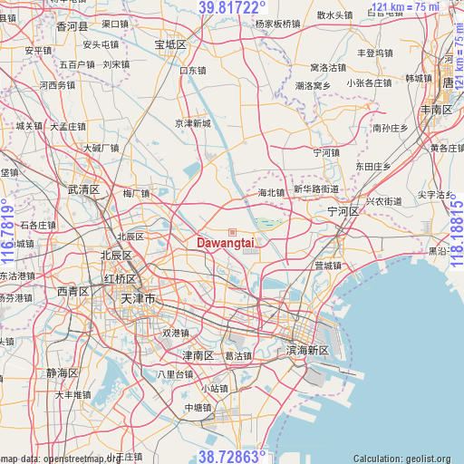
Dawangtai GPS coordinates[2]
39° 16' 30.144" North, 117° 29' 6.072" East
| Map corner | latitude | longitude |
|---|---|---|
| Upper-left | 39.81722°, | 116.7819° |
| Center: | 39.27504°, | 117.48502° |
| Lower-right: | 38.72863°, | 118.18815° |
| Map W x H: | 121×121 km | = 75.2×75.2mi |
| max Lat: | 53.31946° ⇑16% North |
| Dawangtai: | 39.27504° |
| min Lat: | ⇓84% South 18.22056° |
| min Long | Dawangtai | max Long |
| 75.07348° | 117.48502° | 134.28917° |
| W 68.7%⇐ | ⇒31.3% E |
Elevation
Elevation of Dawangtai is 8 m = 26 ft, and this is 476.8 m = 1564 ft below average elevation for this country.
| Max E: |
5622 m = 18445 ft | 92.7% |
| Avg. | 484.8 m = 1591 ft | |
| Dawangtai | 8 m = 26 ft | |
Min E: |
-3 m = -10 ft | 7.3% |
See also: China elevation on elevation.city.
Geographical zone
Dawangtai is located in North temperate zone (between Tropic of Cancer and the Arctic Circle). Distance of this Northern Tropic circle is 1761.1 km =1094.3 mi to South.| Distance of | km | miles | from Dawangtai |
|---|---|---|---|
| North Pole | 5640.1 | 3504.6 | to North |
| Arctic Circle | 3034.2 | 1885.4 | to North |
| Tropic Cancer | 1761.1 | 1094.3 | to South |
| Equator | 4367 | 2713.5 | to South |


Nearby cities:
15 places around Dawangtai: (largest is in red/bold)
• Beihuaidian
7 km =4.3 mi,  105°
105°
• Biaokou
8.1 km =5 mi,  46°
46°
• Chitu
10.7 km =6.6 mi,  221°
221°
• Datangzhuang
14.5 km =9 mi,  342°
342°
• Dongditou
9.7 km =6 mi,  264°
264°
• Erwangzhuang
17.2 km =10.7 mi,  318°
318°
• Fanzhuang
15.8 km =9.8 mi,  234°
234°
• Huantuo
14.9 km =9.3 mi,  248°
248°
• Huozhuangzi
14.9 km =9.3 mi,  277°
277°
• Liukuaizhuang
12.9 km =8 mi, 256°
• Panzhuang
7.3 km =4.5 mi,  348°
348°
• Renfengzhuang
15.8 km =9.8 mi,  75°
75°
• Xiditou
12 km =7.5 mi, 258°
• Xitangtuo
5.3 km =3.3 mi,  2°
2°
• Zaojiacheng
4.2 km =2.6 mi,  273°
273°
Sources, notices
• [Note1] Compared only with cities in China existing in our database
• [Src1] Map data: © OpenStreetMap contributors (CC-BY-SA)
• [Src2] Other city data from geonames.org with taken over terms of usage.
• [Src3] Geographical zone / Annual Mean Temperature by Robert A. Rohde @ Wikipedia
