Chengmagang geodata
Chengmagang (Hubei) is a seat of a fourth-order administrative division; located in China in Asia/Shanghai (GMT+8) time zone. In our database, there are 1268 cities with bigger population. Compared to other cities in China, 57.4% of cities are located further ↓South; 54.2% of cities are located further ←West and 63.9% of cities have higher elevation than Chengmagang. Note1


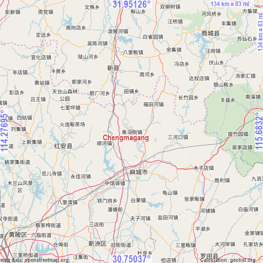
Chengmagang GPS coordinates[2]
31° 21' 9.828" North, 114° 58' 48.252" East
| Map corner | latitude | longitude |
|---|---|---|
| Upper-left | 31.95126°, | 114.27695° |
| Center: | 31.35273°, | 114.98007° |
| Lower-right: | 30.75037°, | 115.6832° |
| Map W x H: | 133.5×133.5 km | = 83×83mi |
| max Lat: | 53.31946° ⇑42.6% North |
| Chengmagang: | 31.35273° |
| min Lat: | ⇓57.4% South 18.22056° |
| min Long | Chengmagang | max Long |
| 75.07348° | 114.98007° | 134.28917° |
| W 54.2%⇐ | ⇒45.8% E |
Elevation
Elevation of Chengmagang is 78 m = 256 ft, and this is 406.8 m = 1335 ft below average elevation for this country.
| Max E: |
5622 m = 18445 ft | 63.9% |
| Avg. | 484.8 m = 1591 ft | |
| Chengmagang | 78 m = 256 ft | |
Min E: |
-3 m = -10 ft | 36.1% |
See also: China elevation on elevation.city.
Geographical zone
Chengmagang is located in North temperate zone (between Tropic of Cancer and the Arctic Circle). Distance of this Northern Tropic circle is 880.2 km =546.9 mi to South.| Distance of | km | miles | from Chengmagang |
|---|---|---|---|
| North Pole | 6521 | 4052 | to North |
| Arctic Circle | 3915.1 | 2432.7 | to North |
| Tropic Cancer | 880.2 | 546.9 | to South |
| Equator | 3486.1 | 2166.2 | to South |


Nearby cities:
15 places around Chengmagang: (largest is in red/bold)
• Futianhe
17.6 km =10.9 mi,  37°
37°
• Gulou
20.1 km =12.5 mi,  164°
164°
• Hong’an Chengguanzhen
32.6 km =20.3 mi,  271°
271°
• Huangtugang
9.8 km =6.1 mi,  69°
69°
• Longchiqiao
18.8 km =11.7 mi,  167°
167°
• Macheng
19.6 km =12.2 mi, 168°
• Nanhu
20.5 km =12.7 mi,  175°
175°
• Qiliping
33.8 km =21 mi,  291°
291°
• Sanhekou
23.4 km =14.5 mi,  96°
96°
• Shunhe
15.5 km =9.6 mi,  248°
248°
• Xinji
31.7 km =19.7 mi,  341°
341°
• Xiyang
20.8 km =12.9 mi,  213°
213°
• Yanjiahe
20.5 km =12.7 mi,  140°
140°
• Yongjiahe
34 km =21.1 mi,  229°
229°
• Zhongguanyi
27.4 km =17 mi,  198°
198°
Sources, notices
• [Note1] Compared only with cities in China existing in our database
• [Src1] Map data: © OpenStreetMap contributors (CC-BY-SA)
• [Src2] Other city data from geonames.org with taken over terms of usage.
• [Src3] Geographical zone / Annual Mean Temperature by Robert A. Rohde @ Wikipedia
