Shunhe geodata
Shunhe (Hubei) is a seat of a fourth-order administrative division; located in China in Asia/Shanghai (GMT+8) time zone. In our database, there are 1268 cities with bigger population. Compared to other cities in China, 57% of cities are located further ↓South; 53.2% of cities are located further ←West and 61.9% of cities have higher elevation than Shunhe. Note1


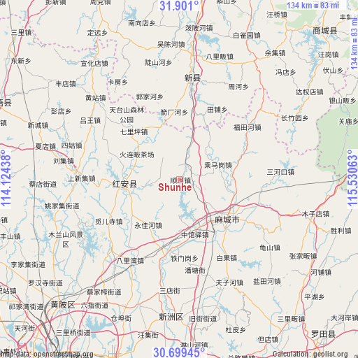
Shunhe GPS coordinates[2]
31° 18' 7.704" North, 114° 49' 39" East
| Map corner | latitude | longitude |
|---|---|---|
| Upper-left | 31.901°, | 114.12438° |
| Center: | 31.30214°, | 114.8275° |
| Lower-right: | 30.69945°, | 115.53063° |
| Map W x H: | 133.6×133.6 km | = 83×83mi |
| max Lat: | 53.31946° ⇑43% North |
| Shunhe: | 31.30214° |
| min Lat: | ⇓57% South 18.22056° |
| min Long | Shunhe | max Long |
| 75.07348° | 114.8275° | 134.28917° |
| W 53.2%⇐ | ⇒46.8% E |
Elevation
Elevation of Shunhe is 88 m = 289 ft, and this is 396.8 m = 1302 ft below average elevation for this country.
| Max E: |
5622 m = 18445 ft | 61.9% |
| Avg. | 484.8 m = 1591 ft | |
| Shunhe | 88 m = 289 ft | |
Min E: |
-3 m = -10 ft | 38.1% |
See also: China elevation on elevation.city.
Geographical zone
Shunhe is located in North temperate zone (between Tropic of Cancer and the Arctic Circle). Distance of this Northern Tropic circle is 874.6 km =543.5 mi to South.| Distance of | km | miles | from Shunhe |
|---|---|---|---|
| North Pole | 6526.6 | 4055.4 | to North |
| Arctic Circle | 3920.7 | 2436.2 | to North |
| Tropic Cancer | 874.6 | 543.5 | to South |
| Equator | 3480.5 | 2162.7 | to South |


Nearby cities:
15 places around Shunhe: (largest is in red/bold)
• Chengmagang
15.5 km =9.6 mi,  68°
68°
• Gaoqiao
27.3 km =17 mi,  246°
246°
• Gulou
24 km =14.9 mi,  124°
124°
• Hong’an Chengguanzhen
19.3 km =12 mi,  290°
290°
• Huangtugang
25.3 km =15.7 mi, 68°
• Longchiqiao
22.4 km =13.9 mi, 124°
• Macheng
22.9 km =14.2 mi,  126°
126°
• Nanhu
22 km =13.7 mi, 132°
• Qiliping
24.8 km =15.4 mi,  316°
316°
• Songbu
26.8 km =16.7 mi,  187°
187°
• Tiemengang
29.2 km =18.1 mi,  176°
176°
• Xinghua
19.4 km =12.1 mi,  262°
262°
• Xiyang
12.2 km =7.6 mi,  165°
165°
• Yongjiahe
20 km =12.4 mi,  214°
214°
• Zhongguanyi
21.2 km =13.2 mi,  164°
164°
Sources, notices
• [Note1] Compared only with cities in China existing in our database
• [Src1] Map data: © OpenStreetMap contributors (CC-BY-SA)
• [Src2] Other city data from geonames.org with taken over terms of usage.
• [Src3] Geographical zone / Annual Mean Temperature by Robert A. Rohde @ Wikipedia
