Fangtai geodata
Fangtai (Jiangxi) is a seat of a fourth-order administrative division; located in China in Asia/Shanghai (GMT+8) time zone. In our database, there are 1268 cities with bigger population. Compared to other cities in China, 80.4% of cities are located further ↑North; 56.3% of cities are located further ←West and 55.6% of cities have lower elevation than Fangtai. Note1


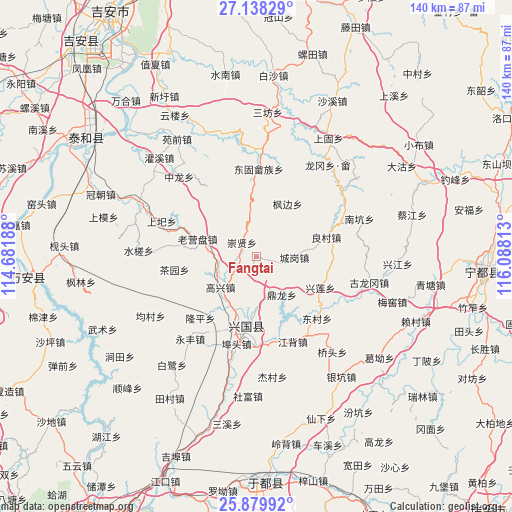
Fangtai GPS coordinates[2]
26° 30' 38.988" North, 115° 23' 6" East
| Map corner | latitude | longitude |
|---|---|---|
| Upper-left | 27.13829°, | 114.68188° |
| Center: | 26.51083°, | 115.385° |
| Lower-right: | 25.87992°, | 116.08813° |
| Map W x H: | 139.9×139.9 km | = 86.9×86.9mi |
| max Lat: | 53.31946° ⇑80.4% North |
| Fangtai: | 26.51083° |
| min Lat: | ⇓19.6% South 18.22056° |
| min Long | Fangtai | max Long |
| 75.07348° | 115.385° | 134.28917° |
| W 56.3%⇐ | ⇒43.7% E |
Elevation
Elevation of Fangtai is 212 m = 696 ft, and this is 272.8 m = 895 ft below average elevation for this country.
| Max E: |
5622 m = 18445 ft | 44.4% |
| Avg. | 484.8 m = 1591 ft | |
| Fangtai | 212 m = 696 ft | |
Min E: |
-3 m = -10 ft | 55.6% |
See also: China elevation on elevation.city.
Geographical zone
Fangtai is located in North temperate zone (between Tropic of Cancer and the Arctic Circle). Distance of this Northern Tropic circle is 341.8 km =212.4 mi to South.| Distance of | km | miles | from Fangtai |
|---|---|---|---|
| North Pole | 7059.3 | 4386.4 | to North |
| Arctic Circle | 4453.4 | 2767.2 | to North |
| Tropic Cancer | 341.8 | 212.4 | to South |
| Equator | 2947.7 | 1831.6 | to South |


Nearby cities:
15 places around Fangtai: (largest is in red/bold)
• Butou
24.9 km =15.5 mi,  190°
190°
• Changgang
16.2 km =10.1 mi, 186°
• Chayuan
22.6 km =14 mi,  260°
260°
• Chenggang
10.2 km =6.3 mi,  91°
91°
• Chongxian
5.9 km =3.7 mi,  315°
315°
• Dinglong
12.7 km =7.9 mi,  146°
146°
• Dongcun
23.4 km =14.5 mi,  134°
134°
• Donggu
23.8 km =14.8 mi,  1°
1°
• Gaoxing
13.4 km =8.3 mi,  229°
229°
• Jiangbei
25.3 km =15.7 mi,  157°
157°
• Laoyingpan
17.6 km =10.9 mi,  287°
287°
• Liangcun
19.7 km =12.2 mi,  74°
74°
• Longping
22.8 km =14.2 mi,  220°
220°
• Shangyi
27.8 km =17.3 mi, 290°
• Xiaolong
23 km =14.3 mi,  325°
325°
Sources, notices
• [Note1] Compared only with cities in China existing in our database
• [Src1] Map data: © OpenStreetMap contributors (CC-BY-SA)
• [Src2] Other city data from geonames.org with taken over terms of usage.
• [Src3] Geographical zone / Annual Mean Temperature by Robert A. Rohde @ Wikipedia
