Tangjiazhuang geodata
Tangjiazhuang (Hebei) is a populated place; located in China in Asia/Shanghai (GMT+8) time zone. With population of 79,489 people, there are 535 cities with bigger population in this country. Compared to other cities in China, 85.5% of cities are located further ↓South; 72.8% of cities are located further ←West and 65.6% of cities have higher elevation than Tangjiazhuang. Note1


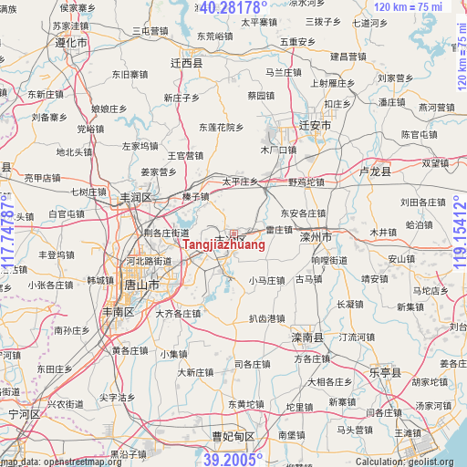
Tangjiazhuang GPS coordinates[2]
39° 44' 35.736" North, 118° 27' 3.564" East
| Map corner | latitude | longitude |
|---|---|---|
| Upper-left | 40.28178°, | 117.74787° |
| Center: | 39.74326°, | 118.45099° |
| Lower-right: | 39.2005°, | 119.15412° |
| Map W x H: | 120.2×120.2 km | = 74.7×74.7mi |
| max Lat: | 53.31946° ⇑14.5% North |
| Tangjiazhuang: | 39.74326° |
| min Lat: | ⇓85.5% South 18.22056° |
| min Long | Tangjiazhuang | max Long |
| 75.07348° | 118.45099° | 134.28917° |
| W 72.8%⇐ | ⇒27.2% E |
Elevation
Elevation of Tangjiazhuang is 70 m = 230 ft, and this is 414.8 m = 1361 ft below average elevation for this country.
| Max E: |
5622 m = 18445 ft | 65.6% |
| Avg. | 484.8 m = 1591 ft | |
| Tangjiazhuang | 70 m = 230 ft | |
Min E: |
-3 m = -10 ft | 34.4% |
See also: Tangjiazhuang elevation on elevation.city.
Geographical zone
Tangjiazhuang is located in North temperate zone (between Tropic of Cancer and the Arctic Circle). Distance of this Northern Tropic circle is 1813.1 km =1126.6 mi to South.| Distance of | km | miles | from Tangjiazhuang |
|---|---|---|---|
| North Pole | 5588 | 3472.2 | to North |
| Arctic Circle | 2982.1 | 1853 | to North |
| Tropic Cancer | 1813.1 | 1126.6 | to South |
| Equator | 4419 | 2745.8 | to South |


Nearby cities:
15 places around Tangjiazhuang: (largest is in red/bold)
• Bencheng
34.4 km =21.4 mi,  141°
141°
• Changli
60 km =37.3 mi,  94°
94°
• Fengrun
30.3 km =18.8 mi,  289°
289°
• Fengtai
63.5 km =39.5 mi,  251°
251°
• Guye
1.7 km =1.1 mi,  211°
211°
• Kaiping
18.5 km =11.5 mi, 246°
• Linxi
3.5 km =2.2 mi,  182°
182°
• Luanzhou
24.1 km =15 mi, 88°
• Miaozhuang
65.9 km =40.9 mi,  237°
237°
• Penguanzhuang
61.8 km =38.4 mi, 242°
• Songling
63.1 km =39.2 mi,  345°
345°
• Tangshan
26 km =16.2 mi, 241°
• Yutian
62.6 km =38.9 mi,  283°
283°
• Zhaogezhuang
4.1 km =2.5 mi,  306°
306°
• Zunhua
64.1 km =39.8 mi,  319°
319°
Sources, notices
• [Note1] Compared only with cities in China existing in our database
• [Src1] Map data: © OpenStreetMap contributors (CC-BY-SA)
• [Src2] Other city data from geonames.org with taken over terms of usage.
• [Src3] Geographical zone / Annual Mean Temperature by Robert A. Rohde @ Wikipedia
