Heping geodata
Heping (Sichuan) is a seat of a fourth-order administrative division; located in China in Asia/Shanghai (GMT+8) time zone. In our database, there are 1268 cities with bigger population. Compared to other cities in China, 61.4% of cities are located further ↓South; 85% of cities are located further →East and 70% of cities have lower elevation than Heping. Note1


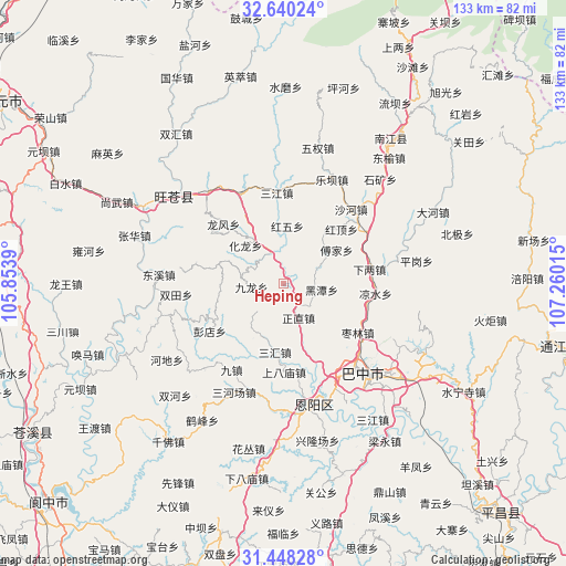
Heping GPS coordinates[2]
32° 2' 46.32" North, 106° 33' 25.272" East
| Map corner | latitude | longitude |
|---|---|---|
| Upper-left | 32.64024°, | 105.8539° |
| Center: | 32.0462°, | 106.55702° |
| Lower-right: | 31.44828°, | 107.26015° |
| Map W x H: | 132.5×132.5 km | = 82.3×82.3mi |
| max Lat: | 53.31946° ⇑38.6% North |
| Heping: | 32.0462° |
| min Lat: | ⇓61.4% South 18.22056° |
| min Long | Heping | max Long |
| 75.07348° | 106.55702° | 134.28917° |
| W 15%⇐ | ⇒85% E |
Elevation
Elevation of Heping is 410 m = 1345 ft, and this is 74.8 m = 245 ft below average elevation for this country.
| Max E: |
5622 m = 18445 ft | 30% |
| Avg. | 484.8 m = 1591 ft | |
| Heping | 410 m = 1345 ft | |
Min E: |
-3 m = -10 ft | 70% |
See also: China elevation on elevation.city.
Geographical zone
Heping is located in North temperate zone (between Tropic of Cancer and the Arctic Circle). Distance of this Northern Tropic circle is 957.3 km =594.8 mi to South.| Distance of | km | miles | from Heping |
|---|---|---|---|
| North Pole | 6443.9 | 4004.1 | to North |
| Arctic Circle | 3838 | 2384.8 | to North |
| Tropic Cancer | 957.3 | 594.8 | to South |
| Equator | 3563.2 | 2214.1 | to South |


Nearby cities:
15 places around Heping: (largest is in red/bold)
• Bazhong
26.4 km =16.4 mi,  138°
138°
• Changchi
16.2 km =10.1 mi,  36°
36°
• Chixi
22.9 km =14.2 mi,  58°
58°
• Fujia
14.8 km =9.2 mi, 57°
• Gaopo
21.2 km =13.2 mi,  283°
283°
• Heitan
9.1 km =5.7 mi,  98°
98°
• Hualong
12.8 km =8 mi,  316°
316°
• Huangmao
15.9 km =9.9 mi,  288°
288°
• Longfeng
20 km =12.4 mi,  314°
314°
• Mumen
7.7 km =4.8 mi,  337°
337°
• Puji
23.5 km =14.6 mi, 335°
• Sanjiang
21.3 km =13.2 mi,  355°
355°
• Shahe
23.6 km =14.7 mi, 42°
• Shima
12.7 km =7.9 mi,  252°
252°
• Xialiang
20.5 km =12.7 mi,  80°
80°
Sources, notices
• [Note1] Compared only with cities in China existing in our database
• [Src1] Map data: © OpenStreetMap contributors (CC-BY-SA)
• [Src2] Other city data from geonames.org with taken over terms of usage.
• [Src3] Geographical zone / Annual Mean Temperature by Robert A. Rohde @ Wikipedia
