Chande geodata
Chande (Hebei) is a seat of a fourth-order administrative division; located in China in Asia/Shanghai (GMT+8) time zone. In our database, there are 1268 cities with bigger population. Compared to other cities in China, 82% of cities are located further ↓South; 52% of cities are located further ←West and 55.2% of cities have higher elevation than Chande. Note1


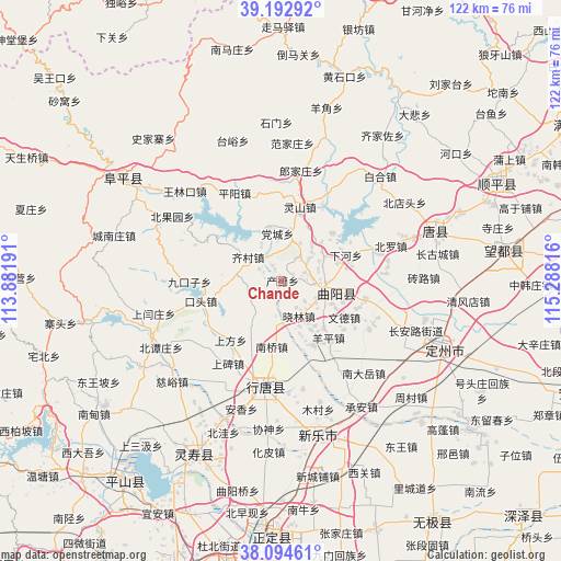
Chande GPS coordinates[2]
38° 38' 45.132" North, 114° 35' 6.108" East
| Map corner | latitude | longitude |
|---|---|---|
| Upper-left | 39.19292°, | 113.88191° |
| Center: | 38.64587°, | 114.58503° |
| Lower-right: | 38.09461°, | 115.28816° |
| Map W x H: | 122.1×122.1 km | = 75.9×75.9mi |
| max Lat: | 53.31946° ⇑18% North |
| Chande: | 38.64587° |
| min Lat: | ⇓82% South 18.22056° |
| min Long | Chande | max Long |
| 75.07348° | 114.58503° | 134.28917° |
| W 52%⇐ | ⇒48% E |
Elevation
Elevation of Chande is 130 m = 427 ft, and this is 354.8 m = 1164 ft below average elevation for this country.
| Max E: |
5622 m = 18445 ft | 55.2% |
| Avg. | 484.8 m = 1591 ft | |
| Chande | 130 m = 427 ft | |
Min E: |
-3 m = -10 ft | 44.8% |
See also: China elevation on elevation.city.
Geographical zone
Chande is located in North temperate zone (between Tropic of Cancer and the Arctic Circle). Distance of this Northern Tropic circle is 1691.1 km =1050.8 mi to South.| Distance of | km | miles | from Chande |
|---|---|---|---|
| North Pole | 5710 | 3548 | to North |
| Arctic Circle | 3104.2 | 1928.9 | to North |
| Tropic Cancer | 1691.1 | 1050.8 | to South |
| Equator | 4297 | 2670 | to South |


Nearby cities:
15 places around Chande: (largest is in red/bold)
• Beihe
7.7 km =4.8 mi,  258°
258°
• Dangcheng
10.1 km =6.3 mi,  353°
353°
• Koutou
18.1 km =11.2 mi, 255°
• Lingshan
16.6 km =10.3 mi,  15°
15°
• Luzhuangzi
9 km =5.6 mi,  120°
120°
• Nanqiao
14.7 km =9.1 mi,  187°
187°
• Qicun
9 km =5.6 mi,  307°
307°
• Shangfang
17.1 km =10.6 mi,  220°
220°
• Wende
16.2 km =10.1 mi, 118°
• Xiahe
15.2 km =9.4 mi,  67°
67°
• Xiaolin
9.1 km =5.7 mi,  153°
153°
• Xiaomu
6.5 km =4 mi,  56°
56°
• Yangping
16.9 km =10.5 mi,  140°
140°
• Yuting
13.9 km =8.6 mi,  208°
208°
• Zhuangke
10.9 km =6.8 mi, 60°
Sources, notices
• [Note1] Compared only with cities in China existing in our database
• [Src1] Map data: © OpenStreetMap contributors (CC-BY-SA)
• [Src2] Other city data from geonames.org with taken over terms of usage.
• [Src3] Geographical zone / Annual Mean Temperature by Robert A. Rohde @ Wikipedia
