Beihe geodata
Beihe (Hebei) is a seat of a fourth-order administrative division; located in China in Asia/Shanghai (GMT+8) time zone. In our database, there are 1268 cities with bigger population. Compared to other cities in China, 82% of cities are located further ↓South; 51.6% of cities are located further ←West and 52% of cities have lower elevation than Beihe. Note1


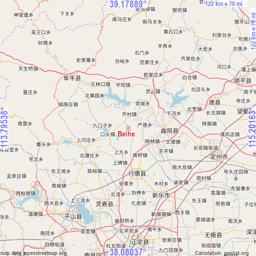
Beihe GPS coordinates[2]
38° 37' 54.228" North, 114° 29' 54.6" East
| Map corner | latitude | longitude |
|---|---|---|
| Upper-left | 39.17889°, | 113.79538° |
| Center: | 38.63173°, | 114.4985° |
| Lower-right: | 38.08037°, | 115.20163° |
| Map W x H: | 122.1×122.1 km | = 75.9×75.9mi |
| max Lat: | 53.31946° ⇑18% North |
| Beihe: | 38.63173° |
| min Lat: | ⇓82% South 18.22056° |
| min Long | Beihe | max Long |
| 75.07348° | 114.4985° | 134.28917° |
| W 51.6%⇐ | ⇒48.4% E |
Elevation
Elevation of Beihe is 181 m = 594 ft, and this is 303.8 m = 997 ft below average elevation for this country.
| Max E: |
5622 m = 18445 ft | 48% |
| Avg. | 484.8 m = 1591 ft | |
| Beihe | 181 m = 594 ft | |
Min E: |
-3 m = -10 ft | 52% |
See also: China elevation on elevation.city.
Geographical zone
Beihe is located in North temperate zone (between Tropic of Cancer and the Arctic Circle). Distance of this Northern Tropic circle is 1689.5 km =1049.8 mi to South.| Distance of | km | miles | from Beihe |
|---|---|---|---|
| North Pole | 5711.6 | 3549 | to North |
| Arctic Circle | 3105.7 | 1929.8 | to North |
| Tropic Cancer | 1689.5 | 1049.8 | to South |
| Equator | 4295.4 | 2669 | to South |


Nearby cities:
15 places around Beihe: (largest is in red/bold)
• Chande
7.7 km =4.8 mi,  78°
78°
• Chengzhai
16.6 km =10.3 mi,  227°
227°
• Dangcheng
13.3 km =8.3 mi,  28°
28°
• Jiukouzi
12.5 km =7.8 mi,  276°
276°
• Koutou
10.4 km =6.5 mi,  253°
253°
• Luzhuangzi
15.6 km =9.7 mi,  101°
101°
• Nanqiao
14.1 km =8.8 mi,  156°
156°
• Pingyang
20.8 km =12.9 mi,  353°
353°
• Qicun
7 km =4.3 mi,  2°
2°
• Shangbei
16.8 km =10.4 mi,  192°
192°
• Shangfang
12 km =7.5 mi,  196°
196°
• Xiaolin
13.3 km =8.3 mi,  119°
119°
• Xiaomu
13.9 km =8.6 mi,  68°
68°
• Yuting
10.7 km =6.6 mi,  174°
174°
• Zhuangke
18.3 km =11.4 mi, 67°
Sources, notices
• [Note1] Compared only with cities in China existing in our database
• [Src1] Map data: © OpenStreetMap contributors (CC-BY-SA)
• [Src2] Other city data from geonames.org with taken over terms of usage.
• [Src3] Geographical zone / Annual Mean Temperature by Robert A. Rohde @ Wikipedia
