Koutou geodata
Koutou (Hebei) is a seat of a fourth-order administrative division; located in China in Asia/Shanghai (GMT+8) time zone. In our database, there are 1268 cities with bigger population. Compared to other cities in China, 82% of cities are located further ↓South; 50.9% of cities are located further ←West and 51.3% of cities have lower elevation than Koutou. Note1


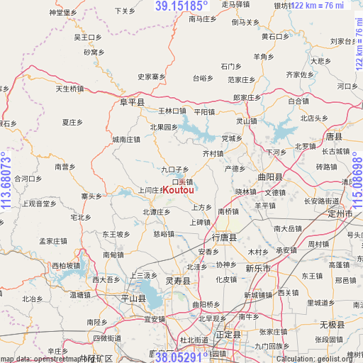
Koutou GPS coordinates[2]
38° 36' 16.128" North, 114° 23' 1.86" East
| Map corner | latitude | longitude |
|---|---|---|
| Upper-left | 39.15185°, | 113.68073° |
| Center: | 38.60448°, | 114.38385° |
| Lower-right: | 38.05291°, | 115.08698° |
| Map W x H: | 122.2×122.2 km | = 75.9×75.9mi |
| max Lat: | 53.31946° ⇑18% North |
| Koutou: | 38.60448° |
| min Lat: | ⇓82% South 18.22056° |
| min Long | Koutou | max Long |
| 75.07348° | 114.38385° | 134.28917° |
| W 50.9%⇐ | ⇒49.1% E |
Elevation
Elevation of Koutou is 175 m = 574 ft, and this is 309.8 m = 1016 ft below average elevation for this country.
| Max E: |
5622 m = 18445 ft | 48.7% |
| Avg. | 484.8 m = 1591 ft | |
| Koutou | 175 m = 574 ft | |
Min E: |
-3 m = -10 ft | 51.3% |
See also: China elevation on elevation.city.
Geographical zone
Koutou is located in North temperate zone (between Tropic of Cancer and the Arctic Circle). Distance of this Northern Tropic circle is 1686.5 km =1047.9 mi to South.| Distance of | km | miles | from Koutou |
|---|---|---|---|
| North Pole | 5714.6 | 3550.9 | to North |
| Arctic Circle | 3108.8 | 1931.7 | to North |
| Tropic Cancer | 1686.5 | 1047.9 | to South |
| Equator | 4292.4 | 2667.2 | to South |


Nearby cities:
15 places around Koutou: (largest is in red/bold)
• Beihe
10.4 km =6.5 mi,  73°
73°
• Beitanzhuang
13.1 km =8.1 mi,  219°
219°
• Chande
18.1 km =11.2 mi,  75°
75°
• Chatou
13.8 km =8.6 mi,  249°
249°
• Chengzhai
8.5 km =5.3 mi,  195°
195°
• Ciyu
18.3 km =11.4 mi, 199°
• Diying
19.5 km =12.1 mi,  165°
165°
• Jiukouzi
5.1 km =3.2 mi,  331°
331°
• Nanqiao
18.4 km =11.4 mi,  122°
122°
• Nanyanchuan
19.7 km =12.2 mi, 222°
• Qicun
14.4 km =8.9 mi,  45°
45°
• Shangbei
14.8 km =9.2 mi,  154°
154°
• Shangfang
10.7 km =6.6 mi,  142°
142°
• Shangyanzhuang
10.8 km =6.7 mi,  256°
256°
• Yuting
13.3 km =8.3 mi, 124°
Sources, notices
• [Note1] Compared only with cities in China existing in our database
• [Src1] Map data: © OpenStreetMap contributors (CC-BY-SA)
• [Src2] Other city data from geonames.org with taken over terms of usage.
• [Src3] Geographical zone / Annual Mean Temperature by Robert A. Rohde @ Wikipedia
