Xinzhou geodata
Xinzhou (Shanxi) is a seat of a third-order administrative division; located in China in Asia/Shanghai (GMT+8) time zone. With population of 154,003 people, there are 284 cities with bigger population in this country. Compared to other cities in China, 81.6% of cities are located further ↓South; 58.9% of cities are located further →East and 82.1% of cities have lower elevation than Xinzhou. Note1


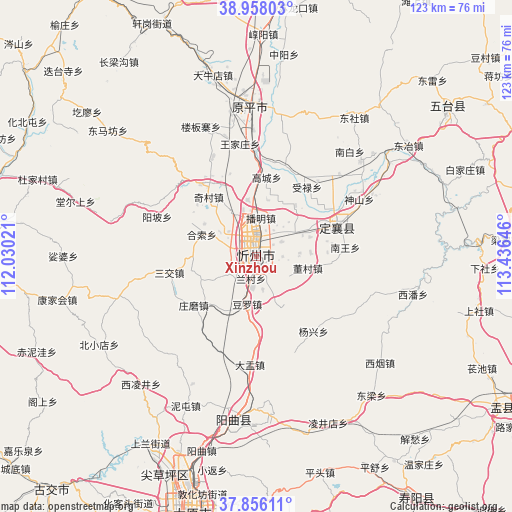
Xinzhou GPS coordinates[2]
38° 24' 33.012" North, 112° 43' 59.988" East
| Map corner | latitude | longitude |
|---|---|---|
| Upper-left | 38.95803°, | 112.03021° |
| Center: | 38.40917°, | 112.73333° |
| Lower-right: | 37.85611°, | 113.43646° |
| Map W x H: | 122.5×122.5 km | = 76.1×76.1mi |
| max Lat: | 53.31946° ⇑18.4% North |
| Xinzhou: | 38.40917° |
| min Lat: | ⇓81.6% South 18.22056° |
| min Long | Xinzhou | max Long |
| 75.07348° | 112.73333° | 134.28917° |
| W 41.1%⇐ | ⇒58.9% E |
Elevation
Elevation of Xinzhou is 794 m = 2605 ft, and this is 309.2 m = 1014 ft above average elevation for this country.
| Max E: |
5622 m = 18445 ft | 17.9% |
| Xinzhou | 794 m 2605 ft | |
| Avg. | 484.8 m = 1591 ft | |
Min E: |
-3 m = -10 ft | 82.1% |
See also: Xinzhou elevation on elevation.city.
Geographical zone
Xinzhou is located in North temperate zone (between Tropic of Cancer and the Arctic Circle). Distance of this Northern Tropic circle is 1664.8 km =1034.5 mi to South.| Distance of | km | miles | from Xinzhou |
|---|---|---|---|
| North Pole | 5736.4 | 3564.4 | to North |
| Arctic Circle | 3130.5 | 1945.2 | to North |
| Tropic Cancer | 1664.8 | 1034.5 | to South |
| Equator | 4270.7 | 2653.7 | to South |


Nearby cities:
15 places around Xinzhou: (largest is in red/bold)
• Chaicun
57.5 km =35.7 mi,  202°
202°
• Dietaisi
63.8 km =39.6 mi,  313°
313°
• Dongmafang
46.7 km =29 mi, 310°
• Huabeitun
63.8 km =39.6 mi,  300°
300°
• Huaidao
52.2 km =32.4 mi, 304°
• Huangzhai
37.7 km =23.4 mi,  189°
189°
• Jinchang
19.3 km =12 mi,  59°
59°
• Julun
57.9 km =36 mi, 195°
• Liuxiang
61.7 km =38.3 mi, 194°
• Qianfeng
65 km =40.4 mi, 196°
• Shijiazhuang
65.1 km =40.5 mi,  286°
286°
• Taicheng
55.9 km =34.7 mi,  50°
50°
• Taiyuan
61.9 km =38.5 mi, 194°
• Xiushui
66.5 km =41.3 mi,  120°
120°
• Yuanping
34.1 km =21.2 mi,  3°
3°
Sources, notices
• [Note1] Compared only with cities in China existing in our database
• [Src1] Map data: © OpenStreetMap contributors (CC-BY-SA)
• [Src2] Other city data from geonames.org with taken over terms of usage.
• [Src3] Geographical zone / Annual Mean Temperature by Robert A. Rohde @ Wikipedia
