Caohe geodata
Caohe (Hubei) is a seat of a third-order administrative division; located in China in Asia/Shanghai (GMT+8) time zone. With population of 67,370 people, there are 638 cities with bigger population in this country. Compared to other cities in China, 51.8% of cities are located further ↑North; 56.6% of cities are located further ←West and 79.8% of cities have higher elevation than Caohe. Note1


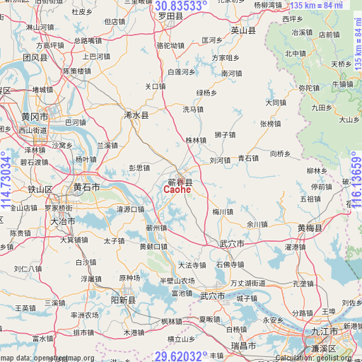
Caohe GPS coordinates[2]
30° 13' 46.92" North, 115° 26' 0.456" East
| Map corner | latitude | longitude |
|---|---|---|
| Upper-left | 30.83533°, | 114.73034° |
| Center: | 30.2297°, | 115.43346° |
| Lower-right: | 29.62032°, | 116.13659° |
| Map W x H: | 135.1×135.1 km | = 83.9×83.9mi |
| max Lat: | 53.31946° ⇑51.8% North |
| Caohe: | 30.2297° |
| min Lat: | ⇓48.2% South 18.22056° |
| min Long | Caohe | max Long |
| 75.07348° | 115.43346° | 134.28917° |
| W 56.6%⇐ | ⇒43.4% E |
Elevation
Elevation of Caohe is 27 m = 89 ft, and this is 457.8 m = 1502 ft below average elevation for this country.
| Max E: |
5622 m = 18445 ft | 79.8% |
| Avg. | 484.8 m = 1591 ft | |
| Caohe | 27 m = 89 ft | |
Min E: |
-3 m = -10 ft | 20.2% |
See also: Caohe elevation on elevation.city.
Geographical zone
Caohe is located in North temperate zone (between Tropic of Cancer and the Arctic Circle). Distance of this Northern Tropic circle is 755.3 km =469.3 mi to South.| Distance of | km | miles | from Caohe |
|---|---|---|---|
| North Pole | 6645.8 | 4129.5 | to North |
| Arctic Circle | 4039.9 | 2510.3 | to North |
| Tropic Cancer | 755.3 | 469.3 | to South |
| Equator | 3361.2 | 2088.6 | to South |


Nearby cities:
15 places around Caohe: (largest is in red/bold)
• Guanyao
17.4 km =10.8 mi,  239°
239°
• Hekou
22.3 km =13.9 mi,  246°
246°
• Hengche
10.9 km =6.8 mi,  323°
323°
• Huangsangkou
26 km =16.2 mi,  202°
202°
• Liuhe
16 km =9.9 mi,  60°
60°
• Meichuan
19.2 km =11.9 mi,  125°
125°
• Pengsi
16.3 km =10.1 mi,  287°
287°
• Qingshi
26.4 km =16.4 mi,  69°
69°
• Qizhou
20.5 km =12.7 mi,  207°
207°
• Shizi
24 km =14.9 mi,  42°
42°
• Siwang
25.2 km =15.7 mi,  153°
153°
• Weiyuankou
22 km =13.7 mi, 240°
• Xisaishan
25.5 km =15.8 mi,  265°
265°
• Zhulin
16.5 km =10.3 mi,  19°
19°
• Zoumaling
2 km =1.2 mi, 198°
In other languages:
- In Chinese: Ts’ao-ho-cheng, Ts’ao-ho, Ch’i-ch’un, Ts’ao-ho-chen, Ts’ao-ho-chien, Ts’ao-chia-ho, 漕河
Sources, notices
• [Note1] Compared only with cities in China existing in our database
• [Src1] Map data: © OpenStreetMap contributors (CC-BY-SA)
• [Src2] Other city data from geonames.org with taken over terms of usage.
• [Src3] Geographical zone / Annual Mean Temperature by Robert A. Rohde @ Wikipedia
