Liuhe geodata
Liuhe (Hubei) is a seat of a fourth-order administrative division; located in China in Asia/Shanghai (GMT+8) time zone. In our database, there are 1268 cities with bigger population. Compared to other cities in China, 51.2% of cities are located further ↑North; 57.4% of cities are located further ←West and 75.3% of cities have higher elevation than Liuhe. Note1


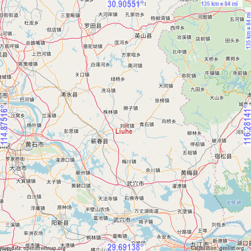
Liuhe GPS coordinates[2]
30° 18' 1.152" North, 115° 34' 41.808" East
| Map corner | latitude | longitude |
|---|---|---|
| Upper-left | 30.90551°, | 114.87516° |
| Center: | 30.30032°, | 115.57828° |
| Lower-right: | 29.69138°, | 116.28141° |
| Map W x H: | 135×135 km | = 83.9×83.9mi |
| max Lat: | 53.31946° ⇑51.2% North |
| Liuhe: | 30.30032° |
| min Lat: | ⇓48.8% South 18.22056° |
| min Long | Liuhe | max Long |
| 75.07348° | 115.57828° | 134.28917° |
| W 57.4%⇐ | ⇒42.6% E |
Elevation
Elevation of Liuhe is 36 m = 118 ft, and this is 448.8 m = 1472 ft below average elevation for this country.
| Max E: |
5622 m = 18445 ft | 75.3% |
| Avg. | 484.8 m = 1591 ft | |
| Liuhe | 36 m = 118 ft | |
Min E: |
-3 m = -10 ft | 24.7% |
See also: China elevation on elevation.city.
Geographical zone
Liuhe is located in North temperate zone (between Tropic of Cancer and the Arctic Circle). Distance of this Northern Tropic circle is 763.2 km =474.2 mi to South.| Distance of | km | miles | from Liuhe |
|---|---|---|---|
| North Pole | 6638 | 4124.7 | to North |
| Arctic Circle | 4032.1 | 2505.4 | to North |
| Tropic Cancer | 763.2 | 474.2 | to South |
| Equator | 3369.1 | 2093.5 | to South |


Nearby cities:
15 places around Liuhe: (largest is in red/bold)
• Caohe
16 km =9.9 mi,  240°
240°
• Datong
30.5 km =19 mi,  44°
44°
• Hengche
20.4 km =12.7 mi,  272°
272°
• Lüyang
25.7 km =16 mi,  350°
350°
• Meichuan
19.1 km =11.9 mi,  174°
174°
• Pengsi
29.6 km =18.4 mi,  264°
264°
• Qingshi
11 km =6.8 mi,  83°
83°
• Shizi
10 km =6.2 mi,  13°
13°
• Siwang
30.4 km =18.9 mi,  184°
184°
• Xiangqiao
17.2 km =10.7 mi, 76°
• Xima
21.4 km =13.3 mi,  332°
332°
• Yuchuan
27.7 km =17.2 mi,  148°
148°
• Zhangbang
23.9 km =14.9 mi,  54°
54°
• Zhulin
11.3 km =7 mi,  312°
312°
• Zoumaling
17.5 km =10.9 mi, 236°
Sources, notices
• [Note1] Compared only with cities in China existing in our database
• [Src1] Map data: © OpenStreetMap contributors (CC-BY-SA)
• [Src2] Other city data from geonames.org with taken over terms of usage.
• [Src3] Geographical zone / Annual Mean Temperature by Robert A. Rohde @ Wikipedia
