Caofang geodata
Caofang (Fujian) is a seat of a fourth-order administrative division; located in China in Asia/Shanghai (GMT+8) time zone. In our database, there are 1268 cities with bigger population. Compared to other cities in China, 82.1% of cities are located further ↑North; 63.8% of cities are located further ←West and 74.2% of cities have lower elevation than Caofang. Note1


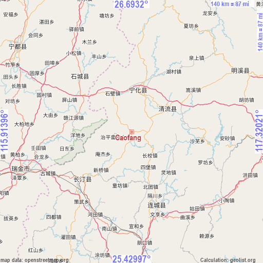
Caofang GPS coordinates[2]
26° 3' 47.844" North, 116° 37' 1.488" East
| Map corner | latitude | longitude |
|---|---|---|
| Upper-left | 26.6932°, | 115.91396° |
| Center: | 26.06329°, | 116.61708° |
| Lower-right: | 25.42997°, | 117.32021° |
| Map W x H: | 140.5×140.5 km | = 87.3×87.3mi |
| max Lat: | 53.31946° ⇑82.1% North |
| Caofang: | 26.06329° |
| min Lat: | ⇓17.9% South 18.22056° |
| min Long | Caofang | max Long |
| 75.07348° | 116.61708° | 134.28917° |
| W 63.8%⇐ | ⇒36.2% E |
Elevation
Elevation of Caofang is 505 m = 1657 ft, and this is 20.2 m = 66 ft above average elevation for this country.
| Max E: |
5622 m = 18445 ft | 25.8% |
| Caofang | 505 m 1657 ft | |
| Avg. | 484.8 m = 1591 ft | |
Min E: |
-3 m = -10 ft | 74.2% |
See also: China elevation on elevation.city.
Geographical zone
Caofang is located in North temperate zone (between Tropic of Cancer and the Arctic Circle). Distance of this Northern Tropic circle is 292 km =181.4 mi to South.| Distance of | km | miles | from Caofang |
|---|---|---|---|
| North Pole | 7109.1 | 4417.4 | to North |
| Arctic Circle | 4503.2 | 2798.2 | to North |
| Tropic Cancer | 292 | 181.4 | to South |
| Equator | 2898 | 1800.7 | to South |


Nearby cities:
15 places around Caofang: (largest is in red/bold)
• Anjie
19.4 km =12.1 mi,  232°
232°
• Chengnan
19.5 km =12.1 mi,  29°
29°
• Cuijiang
22.5 km =14 mi,  8°
8°
• Fangtian
15.5 km =9.6 mi,  330°
330°
• Guanqian
15.9 km =9.9 mi,  207°
207°
• Huaitu
20.5 km =12.7 mi,  314°
314°
• Litian
9.8 km =6.1 mi,  122°
122°
• Longjin
23.7 km =14.7 mi,  56°
56°
• Sibao
20.7 km =12.9 mi,  154°
154°
• Tianyuan
22.8 km =14.2 mi,  92°
92°
• Xianan
23 km =14.3 mi, 10°
• Xiaoxi
15.8 km =9.8 mi,  142°
142°
• Xinggongxia
12.9 km =8 mi, 64°
• Xinshi
23 km =14.3 mi, 333°
• Zhiping Shezu
10.4 km =6.5 mi,  254°
254°
Sources, notices
• [Note1] Compared only with cities in China existing in our database
• [Src1] Map data: © OpenStreetMap contributors (CC-BY-SA)
• [Src2] Other city data from geonames.org with taken over terms of usage.
• [Src3] Geographical zone / Annual Mean Temperature by Robert A. Rohde @ Wikipedia
