Caicun geodata
Caicun (Shanxi) is a seat of a fourth-order administrative division; located in China in Asia/Shanghai (GMT+8) time zone. In our database, there are 1268 cities with bigger population. Compared to other cities in China, 85.5% of cities are located further ↓South; 53.4% of cities are located further →East and 86.6% of cities have lower elevation than Caicun. Note1


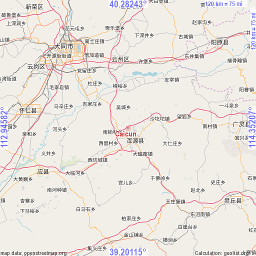
Caicun GPS coordinates[2]
39° 44' 38.076" North, 113° 38' 56.184" East
| Map corner | latitude | longitude |
|---|---|---|
| Upper-left | 40.28243°, | 112.94582° |
| Center: | 39.74391°, | 113.64894° |
| Lower-right: | 39.20115°, | 114.35207° |
| Map W x H: | 120.2×120.2 km | = 74.7×74.7mi |
| max Lat: | 53.31946° ⇑14.5% North |
| Caicun: | 39.74391° |
| min Lat: | ⇓85.5% South 18.22056° |
| min Long | Caicun | max Long |
| 75.07348° | 113.64894° | 134.28917° |
| W 46.6%⇐ | ⇒53.4% E |
Elevation
Elevation of Caicun is 1091 m = 3579 ft, and this is 606.2 m = 1989 ft above average elevation for this country.
| Max E: |
5622 m = 18445 ft | 13.4% |
| Caicun | 1091 m 3579 ft | |
| Avg. | 484.8 m = 1591 ft | |
Min E: |
-3 m = -10 ft | 86.6% |
See also: China elevation on elevation.city.
Geographical zone
Caicun is located in North temperate zone (between Tropic of Cancer and the Arctic Circle). Distance of this Northern Tropic circle is 1813.2 km =1126.7 mi to South.| Distance of | km | miles | from Caicun |
|---|---|---|---|
| North Pole | 5588 | 3472.2 | to North |
| Arctic Circle | 2982.1 | 1853 | to North |
| Tropic Cancer | 1813.2 | 1126.7 | to South |
| Equator | 4419.1 | 2745.9 | to South |


Nearby cities:
15 places around Caicun: (largest is in red/bold)
• Daciyao
13.6 km =8.5 mi,  149°
149°
• Darenzhuang
21.7 km =13.5 mi,  107°
107°
• Fengyu
20.5 km =12.7 mi,  349°
349°
• Guan’er
25.4 km =15.8 mi,  182°
182°
• Huanghuatan
19.3 km =12 mi,  121°
121°
• Jijiazhuang
20.3 km =12.6 mi,  305°
305°
• Nanyulin
7.1 km =4.4 mi,  267°
267°
• Qingciyao
17.1 km =10.6 mi,  143°
143°
• Tuofeng
22.2 km =13.8 mi,  230°
230°
• Wucheng
10.3 km =6.4 mi, 347°
• Xiahan
3.7 km =2.3 mi, 234°
• Xifangcheng
20.5 km =12.7 mi,  224°
224°
• Xiliu
11.5 km =7.1 mi, 233°
• Xinpeicun
17.4 km =10.8 mi, 216°
• Yong’an
6.3 km =3.9 mi, 148°
Sources, notices
• [Note1] Compared only with cities in China existing in our database
• [Src1] Map data: © OpenStreetMap contributors (CC-BY-SA)
• [Src2] Other city data from geonames.org with taken over terms of usage.
• [Src3] Geographical zone / Annual Mean Temperature by Robert A. Rohde @ Wikipedia
