Bajia geodata
Bajia (Guangdong) is a seat of a fourth-order administrative division; located in China in Asia/Shanghai (GMT+8) time zone. In our database, there are 1268 cities with bigger population. Compared to other cities in China, 97.3% of cities are located further ↑North; 65.4% of cities are located further →East and 62.3% of cities have higher elevation than Bajia. Note1


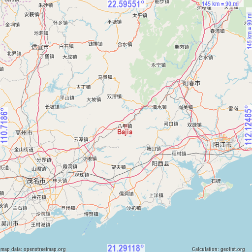
Bajia GPS coordinates[2]
21° 56' 41.424" North, 111° 25' 18.192" East
| Map corner | latitude | longitude |
|---|---|---|
| Upper-left | 22.59551°, | 110.7186° |
| Center: | 21.94484°, | 111.42172° |
| Lower-right: | 21.29118°, | 112.12485° |
| Map W x H: | 145×145 km | = 90.1×90.1mi |
| max Lat: | 53.31946° ⇑97.3% North |
| Bajia: | 21.94484° |
| min Lat: | ⇓2.7% South 18.22056° |
| min Long | Bajia | max Long |
| 75.07348° | 111.42172° | 134.28917° |
| W 34.6%⇐ | ⇒65.4% E |
Elevation
Elevation of Bajia is 86 m = 282 ft, and this is 398.8 m = 1308 ft below average elevation for this country.
| Max E: |
5622 m = 18445 ft | 62.3% |
| Avg. | 484.8 m = 1591 ft | |
| Bajia | 86 m = 282 ft | |
Min E: |
-3 m = -10 ft | 37.7% |
See also: China elevation on elevation.city.
Geographical zone
Bajia is located in North Torrid zone (between Equator and Tropic of Cancer). Distance of this Northern Tropic circle is 165.9 km =103.1 mi to North.| Distance of | km | miles | from Bajia |
|---|---|---|---|
| North Pole | 7567 | 4701.9 | to North |
| Arctic Circle | 4961.1 | 3082.7 | to North |
| Tropic Cancer | 165.9 | 103.1 | to North |
| Equator | 2440 | 1516.1 | to South |


Nearby cities:
15 places around Bajia: (largest is in red/bold)
• Dapo
23.7 km =14.7 mi,  309°
309°
• Hekou
27.1 km =16.8 mi,  84°
84°
• Huangling
30.2 km =18.8 mi,  246°
246°
• Luokeng
23.3 km =14.5 mi,  233°
233°
• Nahuo
19.8 km =12.3 mi, 252°
• Sanjia
15.8 km =9.8 mi,  30°
30°
• Shalang
27.7 km =17.2 mi, 230°
• Shuangjiao
18.3 km =11.4 mi,  339°
339°
• Tangkou
20 km =12.4 mi,  128°
128°
• Tanshui
21.7 km =13.5 mi,  58°
58°
• Wangfu
24.2 km =15 mi,  192°
192°
• Xinxu
26.8 km =16.7 mi,  174°
174°
• Yuntan
27.4 km =17 mi,  255°
255°
• Zhigong
29.9 km =18.6 mi,  138°
138°
• Zhize
29 km =18 mi, 136°
Sources, notices
• [Note1] Compared only with cities in China existing in our database
• [Src1] Map data: © OpenStreetMap contributors (CC-BY-SA)
• [Src2] Other city data from geonames.org with taken over terms of usage.
• [Src3] Geographical zone / Annual Mean Temperature by Robert A. Rohde @ Wikipedia
