Luokeng geodata
Luokeng (Guangdong) is a seat of a fourth-order administrative division; located in China in Asia/Urumqi (GMT+6) time zone. In our database, there are 1268 cities with bigger population. Compared to other cities in China, 97.6% of cities are located further ↑North; 66.1% of cities are located further →East and 72.7% of cities have higher elevation than Luokeng. Note1


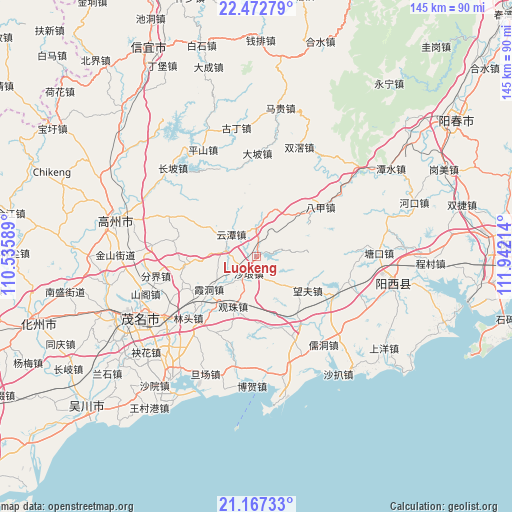
Luokeng GPS coordinates[2]
21° 49' 17.58" North, 111° 14' 20.436" East
| Map corner | latitude | longitude |
|---|---|---|
| Upper-left | 22.47279°, | 110.53589° |
| Center: | 21.82155°, | 111.23901° |
| Lower-right: | 21.16733°, | 111.94214° |
| Map W x H: | 145.2×145.2 km | = 90.2×90.2mi |
| max Lat: | 53.31946° ⇑97.6% North |
| Luokeng: | 21.82155° |
| min Lat: | ⇓2.4% South 18.22056° |
| min Long | Luokeng | max Long |
| 75.07348° | 111.23901° | 134.28917° |
| W 33.9%⇐ | ⇒66.1% E |
Elevation
Elevation of Luokeng is 43 m = 141 ft, and this is 441.8 m = 1449 ft below average elevation for this country.
| Max E: |
5622 m = 18445 ft | 72.7% |
| Avg. | 484.8 m = 1591 ft | |
| Luokeng | 43 m = 141 ft | |
Min E: |
-3 m = -10 ft | 27.3% |
See also: China elevation on elevation.city.
Geographical zone
Luokeng is located in North Torrid zone (between Equator and Tropic of Cancer). Distance of this Northern Tropic circle is 179.6 km =111.6 mi to North.| Distance of | km | miles | from Luokeng |
|---|---|---|---|
| North Pole | 7580.7 | 4710.4 | to North |
| Arctic Circle | 4974.8 | 3091.2 | to North |
| Tropic Cancer | 179.6 | 111.6 | to North |
| Equator | 2426.3 | 1507.6 | to South |


Nearby cities:
15 places around Luokeng: (largest is in red/bold)
• Bajia
23.3 km =14.5 mi,  53°
53°
• Dapo
28.8 km =17.9 mi,  1°
1°
• Genzi
20.7 km =12.9 mi,  263°
263°
• Guanzhu
16.1 km =10 mi,  204°
204°
• Huangling
8.8 km =5.5 mi,  279°
279°
• Lintou
26.2 km =16.3 mi,  228°
228°
• Mata
26.3 km =16.3 mi,  154°
154°
• Nahuo
7.7 km =4.8 mi,  359°
359°
• Shalang
4.6 km =2.9 mi,  211°
211°
• Wangfu
16.8 km =10.4 mi,  126°
126°
• Xiadong
16.5 km =10.3 mi, 233°
• Xieji
28.4 km =17.6 mi,  291°
291°
• Xindong
20.6 km =12.8 mi,  297°
297°
• Xinxu
25.1 km =15.6 mi,  121°
121°
• Yuntan
10.4 km =6.5 mi,  312°
312°
Sources, notices
• [Note1] Compared only with cities in China existing in our database
• [Src1] Map data: © OpenStreetMap contributors (CC-BY-SA)
• [Src2] Other city data from geonames.org with taken over terms of usage.
• [Src3] Geographical zone / Annual Mean Temperature by Robert A. Rohde @ Wikipedia
