Shuangjiao geodata
Shuangjiao (Guangdong) is a seat of a fourth-order administrative division; located in China in Asia/Shanghai (GMT+8) time zone. In our database, there are 1268 cities with bigger population. Compared to other cities in China, 97.1% of cities are located further ↑North; 65.6% of cities are located further →East and 61.1% of cities have higher elevation than Shuangjiao. Note1


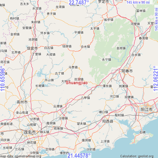
Shuangjiao GPS coordinates[2]
22° 5' 55.464" North, 111° 21' 32.688" East
| Map corner | latitude | longitude |
|---|---|---|
| Upper-left | 22.7487°, | 110.65596° |
| Center: | 22.09874°, | 111.35908° |
| Lower-right: | 21.44578°, | 112.06221° |
| Map W x H: | 144.9×144.9 km | = 90×90mi |
| max Lat: | 53.31946° ⇑97.1% North |
| Shuangjiao: | 22.09874° |
| min Lat: | ⇓2.9% South 18.22056° |
| min Long | Shuangjiao | max Long |
| 75.07348° | 111.35908° | 134.28917° |
| W 34.4%⇐ | ⇒65.6% E |
Elevation
Elevation of Shuangjiao is 92 m = 302 ft, and this is 392.8 m = 1289 ft below average elevation for this country.
| Max E: |
5622 m = 18445 ft | 61.1% |
| Avg. | 484.8 m = 1591 ft | |
| Shuangjiao | 92 m = 302 ft | |
Min E: |
-3 m = -10 ft | 38.9% |
See also: China elevation on elevation.city.
Geographical zone
Shuangjiao is located in North Torrid zone (between Equator and Tropic of Cancer). Distance of this Northern Tropic circle is 148.8 km =92.5 mi to North.| Distance of | km | miles | from Shuangjiao |
|---|---|---|---|
| North Pole | 7549.9 | 4691.3 | to North |
| Arctic Circle | 4944 | 3072.1 | to North |
| Tropic Cancer | 148.8 | 92.5 | to North |
| Equator | 2457.1 | 1526.8 | to South |


Nearby cities:
15 places around Shuangjiao: (largest is in red/bold)
• Bajia
18.3 km =11.4 mi,  159°
159°
• Dapo
12 km =7.5 mi,  260°
260°
• Guding
17.8 km =11.1 mi,  289°
289°
• Heshui
30.5 km =19 mi,  9°
9°
• Luokeng
33.2 km =20.6 mi,  201°
201°
• Magui
12.5 km =7.8 mi,  338°
338°
• Nahuo
26.2 km =16.3 mi,  208°
208°
• Pingshan
27.9 km =17.3 mi,  269°
269°
• Qianpai
31.2 km =19.4 mi, 341°
• Sanjia
15 km =9.3 mi,  103°
103°
• Shenzhen
26.5 km =16.5 mi, 290°
• Tanshui
25.6 km =15.9 mi, 102°
• Xinbao
33.2 km =20.6 mi,  18°
18°
• Yongning
31 km =19.3 mi,  53°
53°
• Yuntan
31.2 km =19.4 mi,  220°
220°
Sources, notices
• [Note1] Compared only with cities in China existing in our database
• [Src1] Map data: © OpenStreetMap contributors (CC-BY-SA)
• [Src2] Other city data from geonames.org with taken over terms of usage.
• [Src3] Geographical zone / Annual Mean Temperature by Robert A. Rohde @ Wikipedia
