Shalang geodata
Shalang (Guangdong) is a seat of a fourth-order administrative division; located in China in Asia/Urumqi (GMT+6) time zone. In our database, there are 1268 cities with bigger population. Compared to other cities in China, 97.6% of cities are located further ↑North; 66.2% of cities are located further →East and 72.7% of cities have higher elevation than Shalang. Note1


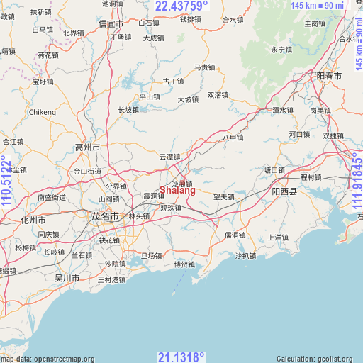
Shalang GPS coordinates[2]
21° 47' 10.248" North, 111° 12' 55.152" East
| Map corner | latitude | longitude |
|---|---|---|
| Upper-left | 22.43759°, | 110.5122° |
| Center: | 21.78618°, | 111.21532° |
| Lower-right: | 21.1318°, | 111.91845° |
| Map W x H: | 145.2×145.2 km | = 90.2×90.2mi |
| max Lat: | 53.31946° ⇑97.6% North |
| Shalang: | 21.78618° |
| min Lat: | ⇓2.4% South 18.22056° |
| min Long | Shalang | max Long |
| 75.07348° | 111.21532° | 134.28917° |
| W 33.8%⇐ | ⇒66.2% E |
Elevation
Elevation of Shalang is 43 m = 141 ft, and this is 441.8 m = 1449 ft below average elevation for this country.
| Max E: |
5622 m = 18445 ft | 72.7% |
| Avg. | 484.8 m = 1591 ft | |
| Shalang | 43 m = 141 ft | |
Min E: |
-3 m = -10 ft | 27.3% |
See also: China elevation on elevation.city.
Geographical zone
Shalang is located in North Torrid zone (between Equator and Tropic of Cancer). Distance of this Northern Tropic circle is 183.5 km =114 mi to North.| Distance of | km | miles | from Shalang |
|---|---|---|---|
| North Pole | 7584.7 | 4712.9 | to North |
| Arctic Circle | 4978.8 | 3093.7 | to North |
| Tropic Cancer | 183.5 | 114 | to North |
| Equator | 2422.4 | 1505.2 | to South |


Nearby cities:
15 places around Shalang: (largest is in red/bold)
• Fenjie
26.1 km =16.2 mi,  266°
266°
• Genzi
18.2 km =11.3 mi, 274°
• Guanzhu
11.5 km =7.1 mi,  202°
202°
• Huangling
8.3 km =5.2 mi,  310°
310°
• Lintou
21.8 km =13.5 mi,  232°
232°
• Luokeng
4.6 km =2.9 mi,  31°
31°
• Mata
24.1 km =15 mi,  145°
145°
• Nahuo
11.9 km =7.4 mi,  11°
11°
• Shuzi
26.9 km =16.7 mi,  178°
178°
• Wangfu
17.1 km =10.6 mi,  110°
110°
• Xiadong
12.4 km =7.7 mi,  241°
241°
• Xindong
20.8 km =12.9 mi, 310°
• Xinxu
25.6 km =15.9 mi, 110°
• Yangjiao
26.8 km =16.7 mi, 243°
• Yuntan
12.1 km =7.5 mi,  334°
334°
Sources, notices
• [Note1] Compared only with cities in China existing in our database
• [Src1] Map data: © OpenStreetMap contributors (CC-BY-SA)
• [Src2] Other city data from geonames.org with taken over terms of usage.
• [Src3] Geographical zone / Annual Mean Temperature by Robert A. Rohde @ Wikipedia
