Baishi geodata
Baishi (Zhejiang) is a seat of a fourth-order administrative division; located in China in Asia/Shanghai (GMT+8) time zone. In our database, there are 1268 cities with bigger population. Compared to other cities in China, 73.3% of cities are located further ↑North; 87.1% of cities are located further ←West and 86.2% of cities have higher elevation than Baishi. Note1


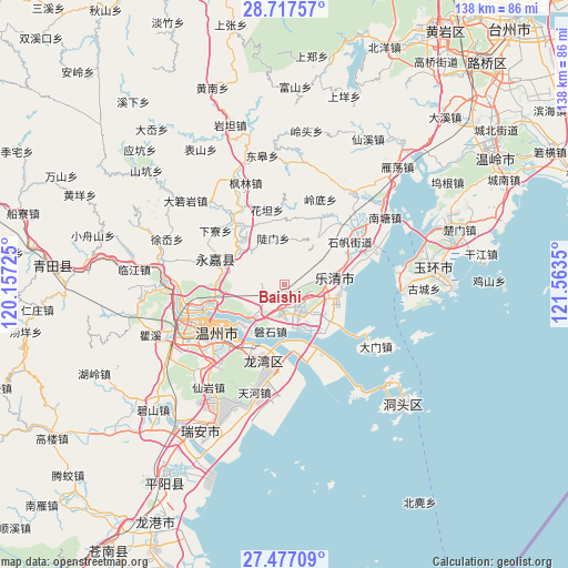
Baishi GPS coordinates[2]
28° 5' 56.832" North, 120° 51' 37.332" East
| Map corner | latitude | longitude |
|---|---|---|
| Upper-left | 28.71757°, | 120.15725° |
| Center: | 28.09912°, | 120.86037° |
| Lower-right: | 27.47709°, | 121.5635° |
| Map W x H: | 137.9×137.9 km | = 85.7×85.7mi |
| max Lat: | 53.31946° ⇑73.3% North |
| Baishi: | 28.09912° |
| min Lat: | ⇓26.7% South 18.22056° |
| min Long | Baishi | max Long |
| 75.07348° | 120.86037° | 134.28917° |
| W 87.1%⇐ | ⇒12.9% E |
Elevation
Elevation of Baishi is 14 m = 46 ft, and this is 470.8 m = 1545 ft below average elevation for this country.
| Max E: |
5622 m = 18445 ft | 86.2% |
| Avg. | 484.8 m = 1591 ft | |
| Baishi | 14 m = 46 ft | |
Min E: |
-3 m = -10 ft | 13.8% |
See also: China elevation on elevation.city.
Geographical zone
Baishi is located in North temperate zone (between Tropic of Cancer and the Arctic Circle). Distance of this Northern Tropic circle is 518.4 km =322.1 mi to South.| Distance of | km | miles | from Baishi |
|---|---|---|---|
| North Pole | 6882.7 | 4276.7 | to North |
| Arctic Circle | 4276.8 | 2657.5 | to North |
| Tropic Cancer | 518.4 | 322.1 | to South |
| Equator | 3124.3 | 1941.3 | to South |


Nearby cities:
15 places around Baishi: (largest is in red/bold)
• Chengbei
8.5 km =5.3 mi,  32°
32°
• Danxi
19.5 km =12.1 mi,  40°
40°
• Doumen
11.7 km =7.3 mi,  346°
346°
• Huatan
18.7 km =11.6 mi, 346°
• Liushi
6.6 km =4.1 mi,  144°
144°
• Puqi
20.2 km =12.6 mi,  68°
68°
• Qidu
13.9 km =8.6 mi,  223°
223°
• Shangtang
18 km =11.2 mi,  290°
290°
• Shatou
15 km =9.3 mi,  317°
317°
• Shifan
19 km =11.8 mi,  56°
56°
• Sidu
15.9 km =9.9 mi, 35°
• Tiancheng
18.6 km =11.6 mi, 64°
• Wengyang
13 km =8.1 mi,  127°
127°
• Wuniu
9.5 km =5.9 mi,  225°
225°
• Xiangyang
9.9 km =6.2 mi, 136°
Sources, notices
• [Note1] Compared only with cities in China existing in our database
• [Src1] Map data: © OpenStreetMap contributors (CC-BY-SA)
• [Src2] Other city data from geonames.org with taken over terms of usage.
• [Src3] Geographical zone / Annual Mean Temperature by Robert A. Rohde @ Wikipedia
