Chengbei geodata
Chengbei (Zhejiang) is a seat of a fourth-order administrative division; located in China in Asia/Shanghai (GMT+8) time zone. In our database, there are 1268 cities with bigger population. Compared to other cities in China, 72.8% of cities are located further ↑North; 87.4% of cities are located further ←West and 74.3% of cities have lower elevation than Chengbei. Note1


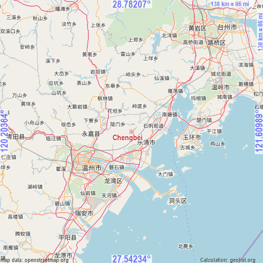
Chengbei GPS coordinates[2]
28° 9' 50.4" North, 120° 54' 24.336" East
| Map corner | latitude | longitude |
|---|---|---|
| Upper-left | 28.78207°, | 120.20364° |
| Center: | 28.164°, | 120.90676° |
| Lower-right: | 27.54234°, | 121.60989° |
| Map W x H: | 137.8×137.8 km | = 85.6×85.6mi |
| max Lat: | 53.31946° ⇑72.8% North |
| Chengbei: | 28.164° |
| min Lat: | ⇓27.2% South 18.22056° |
| min Long | Chengbei | max Long |
| 75.07348° | 120.90676° | 134.28917° |
| W 87.4%⇐ | ⇒12.6% E |
Elevation
Elevation of Chengbei is 506 m = 1660 ft, and this is 21.2 m = 70 ft above average elevation for this country.
| Max E: |
5622 m = 18445 ft | 25.7% |
| Chengbei | 506 m 1660 ft | |
| Avg. | 484.8 m = 1591 ft | |
Min E: |
-3 m = -10 ft | 74.3% |
See also: China elevation on elevation.city.
Geographical zone
Chengbei is located in North temperate zone (between Tropic of Cancer and the Arctic Circle). Distance of this Northern Tropic circle is 525.6 km =326.6 mi to South.| Distance of | km | miles | from Chengbei |
|---|---|---|---|
| North Pole | 6875.5 | 4272.2 | to North |
| Arctic Circle | 4269.6 | 2653 | to North |
| Tropic Cancer | 525.6 | 326.6 | to South |
| Equator | 3131.5 | 1945.8 | to South |


Nearby cities:
15 places around Chengbei: (largest is in red/bold)
• Baishi
8.5 km =5.3 mi,  212°
212°
• Danxi
11.1 km =6.9 mi,  47°
47°
• Doumen
8.4 km =5.2 mi,  299°
299°
• Hongqiao
13.5 km =8.4 mi,  61°
61°
• Huatan
14.1 km =8.8 mi,  321°
321°
• Lingdi
14.2 km =8.8 mi,  16°
16°
• Liushi
12.6 km =7.8 mi,  183°
183°
• Nanyue
17.1 km =10.6 mi,  81°
81°
• Puqi
14.3 km =8.9 mi,  88°
88°
• Shatou
15.2 km =9.4 mi,  284°
284°
• Shifan
11.7 km =7.3 mi,  73°
73°
• Sidu
7.4 km =4.6 mi,  38°
38°
• Tiancheng
12.2 km =7.6 mi, 86°
• Wengyang
16.1 km =10 mi,  158°
158°
• Xiangyang
14.6 km =9.1 mi,  171°
171°
Sources, notices
• [Note1] Compared only with cities in China existing in our database
• [Src1] Map data: © OpenStreetMap contributors (CC-BY-SA)
• [Src2] Other city data from geonames.org with taken over terms of usage.
• [Src3] Geographical zone / Annual Mean Temperature by Robert A. Rohde @ Wikipedia
