Shatou geodata
Shatou (Zhejiang) is a seat of a fourth-order administrative division; located in China in Asia/Shanghai (GMT+8) time zone. In our database, there are 1268 cities with bigger population. Compared to other cities in China, 72.5% of cities are located further ↑North; 86.5% of cities are located further ←West and 82.9% of cities have higher elevation than Shatou. Note1


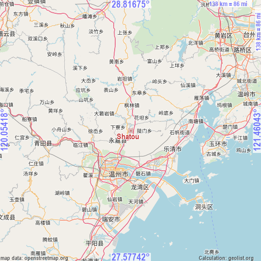
Shatou GPS coordinates[2]
28° 11' 55.968" North, 120° 45' 26.28" East
| Map corner | latitude | longitude |
|---|---|---|
| Upper-left | 28.81675°, | 120.05418° |
| Center: | 28.19888°, | 120.7573° |
| Lower-right: | 27.57742°, | 121.46043° |
| Map W x H: | 137.8×137.8 km | = 85.6×85.6mi |
| max Lat: | 53.31946° ⇑72.5% North |
| Shatou: | 28.19888° |
| min Lat: | ⇓27.5% South 18.22056° |
| min Long | Shatou | max Long |
| 75.07348° | 120.7573° | 134.28917° |
| W 86.5%⇐ | ⇒13.5% E |
Elevation
Elevation of Shatou is 20 m = 66 ft, and this is 464.8 m = 1525 ft below average elevation for this country.
| Max E: |
5622 m = 18445 ft | 82.9% |
| Avg. | 484.8 m = 1591 ft | |
| Shatou | 20 m = 66 ft | |
Min E: |
-3 m = -10 ft | 17.1% |
See also: China elevation on elevation.city.
Geographical zone
Shatou is located in North temperate zone (between Tropic of Cancer and the Arctic Circle). Distance of this Northern Tropic circle is 529.5 km =329 mi to South.| Distance of | km | miles | from Shatou |
|---|---|---|---|
| North Pole | 6871.6 | 4269.8 | to North |
| Arctic Circle | 4265.8 | 2650.6 | to North |
| Tropic Cancer | 529.5 | 329 | to South |
| Equator | 3135.4 | 1948.2 | to South |


Nearby cities:
15 places around Shatou: (largest is in red/bold)
• Baishi
15 km =9.3 mi,  137°
137°
• Chengbei
15.2 km =9.4 mi,  104°
104°
• Daruoyan
16.9 km =10.5 mi,  303°
303°
• Doumen
7.3 km =4.5 mi,  88°
88°
• Fenglin
13.7 km =8.5 mi,  2°
2°
• Huatan
9.2 km =5.7 mi,  39°
39°
• Kunyang
19.8 km =12.3 mi,  287°
287°
• Oubei
19.7 km =12.2 mi,  211°
211°
• Qukou
8.2 km =5.1 mi,  334°
334°
• Shangtang
8.3 km =5.2 mi,  234°
234°
• Sidu
19.4 km =12.1 mi,  84°
84°
• Wuniu
18.1 km =11.2 mi,  169°
169°
• Xialiao
7.1 km =4.4 mi, 287°
• Xu’ao
18.5 km =11.5 mi,  270°
270°
• Yantou
16.1 km =10 mi,  350°
350°
Sources, notices
• [Note1] Compared only with cities in China existing in our database
• [Src1] Map data: © OpenStreetMap contributors (CC-BY-SA)
• [Src2] Other city data from geonames.org with taken over terms of usage.
• [Src3] Geographical zone / Annual Mean Temperature by Robert A. Rohde @ Wikipedia
