Liushi geodata
Liushi (Zhejiang) is a seat of a fourth-order administrative division; located in China in Asia/Shanghai (GMT+8) time zone. In our database, there are 1268 cities with bigger population. Compared to other cities in China, 73.7% of cities are located further ↑North; 87.3% of cities are located further ←West and 88.7% of cities have higher elevation than Liushi. Note1


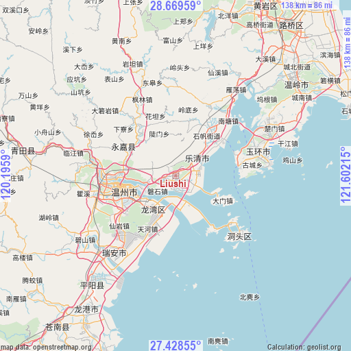
Liushi GPS coordinates[2]
28° 3' 3.096" North, 120° 53' 56.472" East
| Map corner | latitude | longitude |
|---|---|---|
| Upper-left | 28.66959°, | 120.1959° |
| Center: | 28.05086°, | 120.89902° |
| Lower-right: | 27.42855°, | 121.60215° |
| Map W x H: | 138×138 km | = 85.7×85.7mi |
| max Lat: | 53.31946° ⇑73.7% North |
| Liushi: | 28.05086° |
| min Lat: | ⇓26.3% South 18.22056° |
| min Long | Liushi | max Long |
| 75.07348° | 120.89902° | 134.28917° |
| W 87.3%⇐ | ⇒12.7% E |
Elevation
Elevation of Liushi is 11 m = 36 ft, and this is 473.8 m = 1554 ft below average elevation for this country.
| Max E: |
5622 m = 18445 ft | 88.7% |
| Avg. | 484.8 m = 1591 ft | |
| Liushi | 11 m = 36 ft | |
Min E: |
-3 m = -10 ft | 11.3% |
See also: China elevation on elevation.city.
Geographical zone
Liushi is located in North temperate zone (between Tropic of Cancer and the Arctic Circle). Distance of this Northern Tropic circle is 513 km =318.8 mi to South.| Distance of | km | miles | from Liushi |
|---|---|---|---|
| North Pole | 6888.1 | 4280.1 | to North |
| Arctic Circle | 4282.2 | 2660.8 | to North |
| Tropic Cancer | 513 | 318.8 | to South |
| Equator | 3119 | 1938.1 | to South |


Nearby cities:
15 places around Liushi: (largest is in red/bold)
• Baishi
6.6 km =4.1 mi,  324°
324°
• Chengbei
12.6 km =7.8 mi,  3°
3°
• Danxi
22 km =13.7 mi,  24°
24°
• Doumen
17.9 km =11.1 mi,  338°
338°
• Hongqiao
22.8 km =14.2 mi,  33°
33°
• Puqi
19.8 km =12.3 mi,  49°
49°
• Qidu
14.1 km =8.8 mi,  250°
250°
• Shatou
21.5 km =13.4 mi, 319°
• Shifan
19.9 km =12.4 mi,  37°
37°
• Sidu
19.2 km =11.9 mi, 16°
• Tiancheng
18.6 km =11.6 mi, 44°
• Wengyang
7 km =4.3 mi,  110°
110°
• Wuma
23.2 km =14.4 mi,  260°
260°
• Wuniu
10.6 km =6.6 mi, 262°
• Xiangyang
3.5 km =2.2 mi,  121°
121°
Sources, notices
• [Note1] Compared only with cities in China existing in our database
• [Src1] Map data: © OpenStreetMap contributors (CC-BY-SA)
• [Src2] Other city data from geonames.org with taken over terms of usage.
• [Src3] Geographical zone / Annual Mean Temperature by Robert A. Rohde @ Wikipedia
