Anjiang geodata
Anjiang (Hunan) is a populated place; located in China in Asia/Shanghai (GMT+8) time zone. With population of 55,421 people, there are 786 cities with bigger population in this country. Compared to other cities in China, 77.3% of cities are located further ↑North; 70.7% of cities are located further →East and 53.8% of cities have lower elevation than Anjiang. Note1


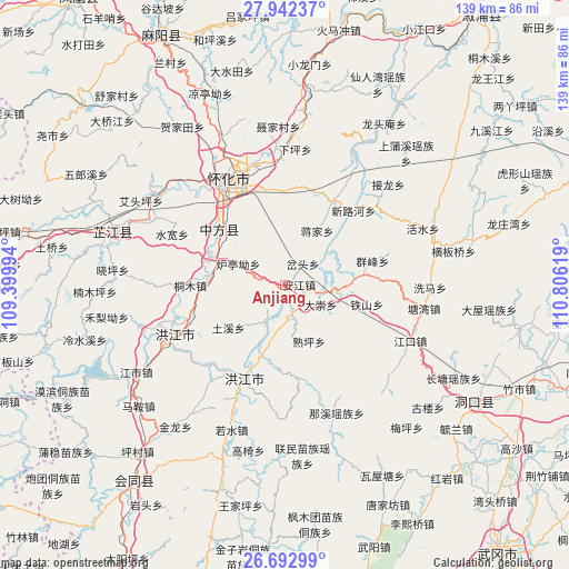
Anjiang GPS coordinates[2]
27° 19' 9.984" North, 110° 6' 11.016" East
| Map corner | latitude | longitude |
|---|---|---|
| Upper-left | 27.94237°, | 109.39994° |
| Center: | 27.31944°, | 110.10306° |
| Lower-right: | 26.69299°, | 110.80619° |
| Map W x H: | 138.9×138.9 km | = 86.3×86.3mi |
| max Lat: | 53.31946° ⇑77.3% North |
| Anjiang: | 27.31944° |
| min Lat: | ⇓22.7% South 18.22056° |
| min Long | Anjiang | max Long |
| 75.07348° | 110.10306° | 134.28917° |
| W 29.3%⇐ | ⇒70.7% E |
Elevation
Elevation of Anjiang is 196 m = 643 ft, and this is 288.8 m = 948 ft below average elevation for this country.
| Max E: |
5622 m = 18445 ft | 46.2% |
| Avg. | 484.8 m = 1591 ft | |
| Anjiang | 196 m = 643 ft | |
Min E: |
-3 m = -10 ft | 53.8% |
See also: Anjiang elevation on elevation.city.
Geographical zone
Anjiang is located in North temperate zone (between Tropic of Cancer and the Arctic Circle). Distance of this Northern Tropic circle is 431.7 km =268.2 mi to South.| Distance of | km | miles | from Anjiang |
|---|---|---|---|
| North Pole | 6969.4 | 4330.6 | to North |
| Arctic Circle | 4363.5 | 2711.4 | to North |
| Tropic Cancer | 431.7 | 268.2 | to South |
| Equator | 3037.6 | 1887.5 | to South |


Nearby cities:
15 places around Anjiang: (largest is in red/bold)
• Daping
20 km =12.4 mi,  83°
83°
• Hongjiang
25.6 km =15.9 mi,  204°
204°
• Huaihua
28.8 km =17.9 mi,  340°
340°
• Jiangkou
33 km =20.5 mi,  115°
115°
• Luojiu
36.3 km =22.6 mi,  306°
306°
• Luyang
33.9 km =21.1 mi,  359°
359°
• Pailou’ao
18.4 km =11.4 mi,  277°
277°
• Qiancheng
36.6 km =22.7 mi,  245°
245°
• Ruoshui
37.8 km =23.5 mi, 200°
• Shawan
15.1 km =9.4 mi,  209°
209°
• Shuangxi
26.5 km =16.5 mi, 247°
• Shuping
14.6 km =9.1 mi,  168°
168°
• Tiepo
31.3 km =19.4 mi,  60°
60°
• Tongwan
33.8 km =21 mi,  30°
30°
• Zhongfang
19.7 km =12.2 mi,  301°
301°
Sources, notices
• [Note1] Compared only with cities in China existing in our database
• [Src1] Map data: © OpenStreetMap contributors (CC-BY-SA)
• [Src2] Other city data from geonames.org with taken over terms of usage.
• [Src3] Geographical zone / Annual Mean Temperature by Robert A. Rohde @ Wikipedia
