Luyang geodata
Luyang (Hunan) is a populated place; located in China in Asia/Shanghai (GMT+8) time zone. With population of 3,150 people, there are 937 cities with bigger population in this country. Compared to other cities in China, 76.1% of cities are located further ↑North; 70.7% of cities are located further →East and 60.2% of cities have lower elevation than Luyang. Note1


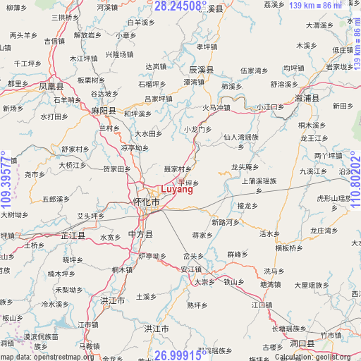
Luyang GPS coordinates[2]
27° 37' 26.004" North, 110° 5' 56.004" East
| Map corner | latitude | longitude |
|---|---|---|
| Upper-left | 28.24508°, | 109.39577° |
| Center: | 27.62389°, | 110.09889° |
| Lower-right: | 26.99915°, | 110.80202° |
| Map W x H: | 138.5×138.5 km | = 86.1×86.1mi |
| max Lat: | 53.31946° ⇑76.1% North |
| Luyang: | 27.62389° |
| min Lat: | ⇓23.9% South 18.22056° |
| min Long | Luyang | max Long |
| 75.07348° | 110.09889° | 134.28917° |
| W 29.3%⇐ | ⇒70.7% E |
Elevation
Elevation of Luyang is 261 m = 856 ft, and this is 223.8 m = 734 ft below average elevation for this country.
| Max E: |
5622 m = 18445 ft | 39.8% |
| Avg. | 484.8 m = 1591 ft | |
| Luyang | 261 m = 856 ft | |
Min E: |
-3 m = -10 ft | 60.2% |
See also: China elevation on elevation.city.
Geographical zone
Luyang is located in North temperate zone (between Tropic of Cancer and the Arctic Circle). Distance of this Northern Tropic circle is 465.6 km =289.3 mi to South.| Distance of | km | miles | from Luyang |
|---|---|---|---|
| North Pole | 6935.6 | 4309.6 | to North |
| Arctic Circle | 4329.7 | 2690.4 | to North |
| Tropic Cancer | 465.6 | 289.3 | to South |
| Equator | 3071.5 | 1908.5 | to South |


Nearby cities:
15 places around Luyang: (largest is in red/bold)
• Anjiang
33.9 km =21.1 mi,  179°
179°
• Anping
27 km =16.8 mi,  3°
3°
• Huaihua
11.5 km =7.1 mi,  234°
234°
• Huangjin’ao
15.1 km =9.4 mi,  282°
282°
• Huangxikou
30.1 km =18.7 mi,  69°
69°
• Huaqiao
10.3 km =6.4 mi,  24°
24°
• Huomachong
31.6 km =19.6 mi, 24°
• Lanli
34.2 km =21.3 mi,  328°
328°
• Longtou’an
23.9 km =14.9 mi,  77°
77°
• Luojiu
31 km =19.3 mi,  247°
247°
• Tiepo
33.1 km =20.6 mi,  123°
123°
• Tongwan
18.2 km =11.3 mi,  105°
105°
• Xianrenwan
27 km =16.8 mi,  57°
57°
• Xiaolongmen
20.7 km =12.9 mi, 17°
• Zhongfang
28.8 km =17.9 mi,  214°
214°
Sources, notices
• [Note1] Compared only with cities in China existing in our database
• [Src1] Map data: © OpenStreetMap contributors (CC-BY-SA)
• [Src2] Other city data from geonames.org with taken over terms of usage.
• [Src3] Geographical zone / Annual Mean Temperature by Robert A. Rohde @ Wikipedia
