Zhongfang geodata
Zhongfang (Hunan) is a seat of a third-order administrative division; located in China in Asia/Shanghai (GMT+8) time zone. With population of 1,360 people, there are 1114 cities with bigger population in this country. Compared to other cities in China, 77% of cities are located further ↑North; 71.6% of cities are located further →East and 55.2% of cities have lower elevation than Zhongfang. Note1


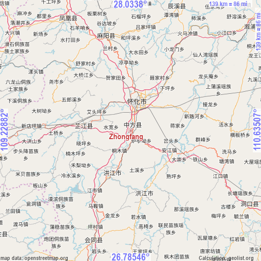
Zhongfang GPS coordinates[2]
27° 24' 41.004" North, 109° 55' 54.984" East
| Map corner | latitude | longitude |
|---|---|---|
| Upper-left | 28.0338°, | 109.22882° |
| Center: | 27.41139°, | 109.93194° |
| Lower-right: | 26.78546°, | 110.63507° |
| Map W x H: | 138.8×138.8 km | = 86.2×86.2mi |
| max Lat: | 53.31946° ⇑77% North |
| Zhongfang: | 27.41139° |
| min Lat: | ⇓23% South 18.22056° |
| min Long | Zhongfang | max Long |
| 75.07348° | 109.93194° | 134.28917° |
| W 28.4%⇐ | ⇒71.6% E |
Elevation
Elevation of Zhongfang is 208 m = 682 ft, and this is 276.8 m = 908 ft below average elevation for this country.
| Max E: |
5622 m = 18445 ft | 44.8% |
| Avg. | 484.8 m = 1591 ft | |
| Zhongfang | 208 m = 682 ft | |
Min E: |
-3 m = -10 ft | 55.2% |
See also: China elevation on elevation.city.
Geographical zone
Zhongfang is located in North temperate zone (between Tropic of Cancer and the Arctic Circle). Distance of this Northern Tropic circle is 441.9 km =274.6 mi to South.| Distance of | km | miles | from Zhongfang |
|---|---|---|---|
| North Pole | 6959.2 | 4324.2 | to North |
| Arctic Circle | 4353.3 | 2705 | to North |
| Tropic Cancer | 441.9 | 274.6 | to South |
| Equator | 3047.9 | 1893.9 | to South |


Nearby cities:
15 places around Zhongfang: (largest is in red/bold)
• Anjiang
19.7 km =12.2 mi,  121°
121°
• Hongjiang
34.1 km =21.2 mi,  169°
169°
• Huaihua
18.3 km =11.4 mi,  22°
22°
• Huangjin’ao
27 km =16.8 mi,  3°
3°
• Jiangkouxu
36.9 km =22.9 mi,  328°
328°
• Luojiu
16.8 km =10.4 mi,  313°
313°
• Luyang
28.8 km =17.9 mi,  34°
34°
• Nanmuping
27.4 km =17 mi,  245°
245°
• Pailou’ao
8 km =5 mi,  189°
189°
• Qiancheng
30.1 km =18.7 mi,  213°
213°
• Shawan
25.3 km =15.7 mi,  157°
157°
• Shuangxi
21.7 km =13.5 mi,  200°
200°
• Shuping
31.5 km =19.6 mi,  141°
141°
• Xiaoping
22.5 km =14 mi,  256°
256°
• Zhijiang
27.4 km =17 mi,  280°
280°
Sources, notices
• [Note1] Compared only with cities in China existing in our database
• [Src1] Map data: © OpenStreetMap contributors (CC-BY-SA)
• [Src2] Other city data from geonames.org with taken over terms of usage.
• [Src3] Geographical zone / Annual Mean Temperature by Robert A. Rohde @ Wikipedia
