Foya geodata
Foya (Gansu) is a seat of a fourth-order administrative division; located in China in Asia/Shanghai (GMT+8) time zone. In our database, there are 1268 cities with bigger population. Compared to other cities in China, 67.8% of cities are located further ↓South; 88.6% of cities are located further →East and 89.8% of cities have lower elevation than Foya. Note1


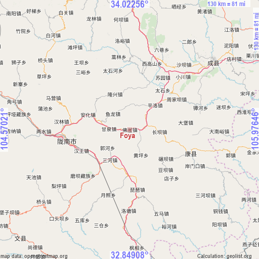
Foya GPS coordinates[2]
33° 26' 16.08" North, 105° 16' 23.988" East
| Map corner | latitude | longitude |
|---|---|---|
| Upper-left | 34.02256°, | 104.57021° |
| Center: | 33.4378°, | 105.27333° |
| Lower-right: | 32.84908°, | 105.97646° |
| Map W x H: | 130.5×130.5 km | = 81.1×81.1mi |
| max Lat: | 53.31946° ⇑32.2% North |
| Foya: | 33.4378° |
| min Lat: | ⇓67.8% South 18.22056° |
| min Long | Foya | max Long |
| 75.07348° | 105.27333° | 134.28917° |
| W 11.4%⇐ | ⇒88.6% E |
Elevation
Elevation of Foya is 1340 m = 4396 ft, and this is 855.2 m = 2806 ft above average elevation for this country.
| Max E: |
5622 m = 18445 ft | 10.2% |
| Foya | 1340 m 4396 ft | |
| Avg. | 484.8 m = 1591 ft | |
Min E: |
-3 m = -10 ft | 89.8% |
See also: China elevation on elevation.city.
Geographical zone
Foya is located in North temperate zone (between Tropic of Cancer and the Arctic Circle). Distance of this Northern Tropic circle is 1112 km =691 mi to South.| Distance of | km | miles | from Foya |
|---|---|---|---|
| North Pole | 6289.1 | 3907.9 | to North |
| Arctic Circle | 3683.2 | 2288.6 | to North |
| Tropic Cancer | 1112 | 691 | to South |
| Equator | 3717.9 | 2310.2 | to South |


Nearby cities:
15 places around Foya: (largest is in red/bold)
• Anhua
22.2 km =13.8 mi,  289°
289°
• Changba
15 km =9.3 mi,  93°
93°
• Douping
19.8 km =12.3 mi,  63°
63°
• Ganquan
10.5 km =6.5 mi,  272°
272°
• Guohe
15.1 km =9.4 mi,  230°
230°
• Huangping
14 km =8.7 mi,  157°
157°
• Longba
20.9 km =13 mi,  5°
5°
• Longfeng
21.6 km =13.4 mi,  257°
257°
• Longxing
19.4 km =12.1 mi,  337°
337°
• Pingluo
17.7 km =11 mi,  45°
45°
• Sanhe
18.3 km =11.4 mi,  212°
212°
• Wangguan
8.5 km =5.3 mi,  73°
73°
• Xiongchi
6.4 km =4 mi,  123°
123°
• Yuhuang
16.8 km =10.4 mi,  195°
195°
• Yulong
11.7 km =7.3 mi,  313°
313°
Sources, notices
• [Note1] Compared only with cities in China existing in our database
• [Src1] Map data: © OpenStreetMap contributors (CC-BY-SA)
• [Src2] Other city data from geonames.org with taken over terms of usage.
• [Src3] Geographical zone / Annual Mean Temperature by Robert A. Rohde @ Wikipedia
