Yulong geodata
Yulong (Gansu) is a seat of a fourth-order administrative division; located in China in Asia/Shanghai (GMT+8) time zone. In our database, there are 1268 cities with bigger population. Compared to other cities in China, 68.1% of cities are located further ↓South; 88.8% of cities are located further →East and 94.7% of cities have lower elevation than Yulong. Note1


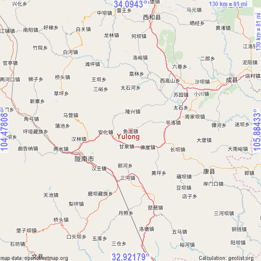
Yulong GPS coordinates[2]
33° 30' 36.108" North, 105° 10' 52.32" East
| Map corner | latitude | longitude |
|---|---|---|
| Upper-left | 34.0943°, | 104.47808° |
| Center: | 33.51003°, | 105.1812° |
| Lower-right: | 32.92179°, | 105.88433° |
| Map W x H: | 130.4×130.4 km | = 81×81mi |
| max Lat: | 53.31946° ⇑31.9% North |
| Yulong: | 33.51003° |
| min Lat: | ⇓68.1% South 18.22056° |
| min Long | Yulong | max Long |
| 75.07348° | 105.1812° | 134.28917° |
| W 11.2%⇐ | ⇒88.8% E |
Elevation
Elevation of Yulong is 1988 m = 6522 ft, and this is 1503.2 m = 4932 ft above average elevation for this country.
| Max E: |
5622 m = 18445 ft | 5.3% |
| Yulong | 1988 m 6522 ft | |
| Avg. | 484.8 m = 1591 ft | |
Min E: |
-3 m = -10 ft | 94.7% |
See also: China elevation on elevation.city.
Geographical zone
Yulong is located in North temperate zone (between Tropic of Cancer and the Arctic Circle). Distance of this Northern Tropic circle is 1120 km =695.9 mi to South.| Distance of | km | miles | from Yulong |
|---|---|---|---|
| North Pole | 6281.1 | 3902.9 | to North |
| Arctic Circle | 3675.2 | 2283.7 | to North |
| Tropic Cancer | 1120 | 695.9 | to South |
| Equator | 3726 | 2315.2 | to South |


Nearby cities:
15 places around Yulong: (largest is in red/bold)
• Anhua
12.4 km =7.7 mi,  267°
267°
• Foya
11.7 km =7.3 mi,  133°
133°
• Ganquan
7.8 km =4.8 mi,  194°
194°
• Guohe
17.9 km =11.1 mi, 189°
• Hanwang
24.4 km =15.2 mi,  220°
220°
• Longba
16.5 km =10.3 mi,  39°
39°
• Longfeng
17.9 km =11.1 mi, 224°
• Longxing
9.9 km =6.2 mi,  6°
6°
• Majie
21.5 km =13.4 mi,  254°
254°
• Pingluo
21.7 km =13.5 mi,  78°
78°
• Sanhe
23.5 km =14.6 mi,  183°
183°
• Taishihe
21.8 km =13.5 mi,  0°
0°
• Wangguan
17.7 km =11 mi,  108°
108°
• Xiongchi
18.1 km =11.2 mi, 129°
• Yuhuang
24.5 km =15.2 mi,  170°
170°
Sources, notices
• [Note1] Compared only with cities in China existing in our database
• [Src1] Map data: © OpenStreetMap contributors (CC-BY-SA)
• [Src2] Other city data from geonames.org with taken over terms of usage.
• [Src3] Geographical zone / Annual Mean Temperature by Robert A. Rohde @ Wikipedia
