Shangzheng geodata
Shangzheng (Zhejiang) is a seat of a fourth-order administrative division; located in China in Asia/Shanghai (GMT+8) time zone. In our database, there are 1268 cities with bigger population. Compared to other cities in China, 68.9% of cities are located further ↑North; 87.4% of cities are located further ←West and 57.5% of cities have higher elevation than Shangzheng. Note1


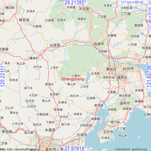
Shangzheng GPS coordinates[2]
28° 35' 53.988" North, 120° 55' 27.228" East
| Map corner | latitude | longitude |
|---|---|---|
| Upper-left | 29.21385°, | 120.22111° |
| Center: | 28.59833°, | 120.92423° |
| Lower-right: | 27.97918°, | 121.62736° |
| Map W x H: | 137.3×137.3 km | = 85.3×85.3mi |
| max Lat: | 53.31946° ⇑68.9% North |
| Shangzheng: | 28.59833° |
| min Lat: | ⇓31.1% South 18.22056° |
| min Long | Shangzheng | max Long |
| 75.07348° | 120.92423° | 134.28917° |
| W 87.4%⇐ | ⇒12.6% E |
Elevation
Elevation of Shangzheng is 114 m = 374 ft, and this is 370.8 m = 1217 ft below average elevation for this country.
| Max E: |
5622 m = 18445 ft | 57.5% |
| Avg. | 484.8 m = 1591 ft | |
| Shangzheng | 114 m = 374 ft | |
Min E: |
-3 m = -10 ft | 42.5% |
See also: China elevation on elevation.city.
Geographical zone
Shangzheng is located in North temperate zone (between Tropic of Cancer and the Arctic Circle). Distance of this Northern Tropic circle is 573.9 km =356.6 mi to South.| Distance of | km | miles | from Shangzheng |
|---|---|---|---|
| North Pole | 6827.2 | 4242.2 | to North |
| Arctic Circle | 4221.3 | 2623 | to North |
| Tropic Cancer | 573.9 | 356.6 | to South |
| Equator | 3179.8 | 1975.8 | to South |


Nearby cities:
15 places around Shangzheng: (largest is in red/bold)
• Beiyang
18 km =11.2 mi,  83°
83°
• Fushan
8.3 km =5.2 mi,  206°
206°
• Fuxi
17.5 km =10.9 mi,  148°
148°
• Lingtou
18.2 km =11.3 mi,  183°
183°
• Maoshe
19.6 km =12.2 mi,  97°
97°
• Ningxi
4.6 km =2.9 mi, 102°
• Pingtian
15.7 km =9.8 mi,  112°
112°
• Shangyang
11.5 km =7.1 mi,  139°
139°
• Shangzhang
20.8 km =12.9 mi,  291°
291°
• Toutuo
21.6 km =13.4 mi, 80°
• Xiyuan
22.1 km =13.7 mi,  202°
202°
• Yutou
9.2 km =5.7 mi,  57°
57°
• Zhangxi
19.3 km =12 mi,  228°
228°
• Zhiren
22.3 km =13.9 mi,  122°
122°
• Zhuxi
16.7 km =10.4 mi,  328°
328°
Sources, notices
• [Note1] Compared only with cities in China existing in our database
• [Src1] Map data: © OpenStreetMap contributors (CC-BY-SA)
• [Src2] Other city data from geonames.org with taken over terms of usage.
• [Src3] Geographical zone / Annual Mean Temperature by Robert A. Rohde @ Wikipedia
