Huwu geodata
Huwu (Zhejiang) is a seat of a fourth-order administrative division; located in China in Asia/Shanghai (GMT+8) time zone. In our database, there are 1268 cities with bigger population. Compared to other cities in China, 70.7% of cities are located further ↑North; 88.6% of cities are located further ←West and 85.5% of cities have higher elevation than Huwu. Note1


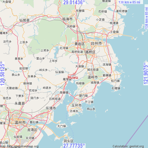
Huwu GPS coordinates[2]
28° 23' 51.576" North, 121° 12' 15.732" East
| Map corner | latitude | longitude |
|---|---|---|
| Upper-left | 29.01436°, | 120.50125° |
| Center: | 28.39766°, | 121.20437° |
| Lower-right: | 27.77735°, | 121.9075° |
| Map W x H: | 137.5×137.5 km | = 85.4×85.4mi |
| max Lat: | 53.31946° ⇑70.7% North |
| Huwu: | 28.39766° |
| min Lat: | ⇓29.3% South 18.22056° |
| min Long | Huwu | max Long |
| 75.07348° | 121.20437° | 134.28917° |
| W 88.6%⇐ | ⇒11.4% E |
Elevation
Elevation of Huwu is 15 m = 49 ft, and this is 469.8 m = 1541 ft below average elevation for this country.
| Max E: |
5622 m = 18445 ft | 85.5% |
| Avg. | 484.8 m = 1591 ft | |
| Huwu | 15 m = 49 ft | |
Min E: |
-3 m = -10 ft | 14.5% |
See also: China elevation on elevation.city.
Geographical zone
Huwu is located in North temperate zone (between Tropic of Cancer and the Arctic Circle). Distance of this Northern Tropic circle is 551.6 km =342.7 mi to South.| Distance of | km | miles | from Huwu |
|---|---|---|---|
| North Pole | 6849.5 | 4256.1 | to North |
| Arctic Circle | 4243.7 | 2636.9 | to North |
| Tropic Cancer | 551.6 | 342.7 | to South |
| Equator | 3157.5 | 1962 | to South |


Nearby cities:
15 places around Huwu: (largest is in red/bold)
• Chengbei
17.6 km =10.9 mi,  73°
73°
• Chengdong
17.2 km =10.7 mi,  89°
89°
• Chengxi
14.7 km =9.1 mi,  95°
95°
• Dajing
5.1 km =3.2 mi,  284°
284°
• Daxi
8.9 km =5.5 mi,  30°
30°
• Hengfeng
13.9 km =8.6 mi, 73°
• Longxi
15.7 km =9.8 mi,  269°
269°
• Qingjiang
16.8 km =10.4 mi,  216°
216°
• Shuangfeng
7.9 km =4.9 mi,  287°
287°
• Taiping
15.7 km =9.8 mi, 101°
• Wugen
10.3 km =6.4 mi,  142°
142°
• Xianxi
13.7 km =8.5 mi, 279°
• Yandang
7.9 km =4.9 mi,  232°
232°
• Zhen’an
8.7 km =5.4 mi,  331°
331°
• Zhiren
13.5 km =8.4 mi,  320°
320°
Sources, notices
• [Note1] Compared only with cities in China existing in our database
• [Src1] Map data: © OpenStreetMap contributors (CC-BY-SA)
• [Src2] Other city data from geonames.org with taken over terms of usage.
• [Src3] Geographical zone / Annual Mean Temperature by Robert A. Rohde @ Wikipedia
