Fengjiang geodata
Fengjiang (Zhejiang) is a seat of a fourth-order administrative division; located in China in Asia/Shanghai (GMT+8) time zone. In our database, there are 1268 cities with bigger population. Compared to other cities in China, 69.4% of cities are located further ↑North; 89.5% of cities are located further ←West and 92.7% of cities have higher elevation than Fengjiang. Note1


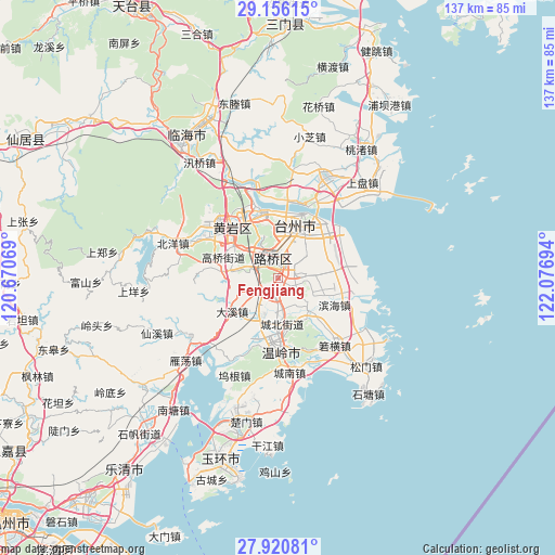
Fengjiang GPS coordinates[2]
28° 32' 25.044" North, 121° 22' 25.716" East
| Map corner | latitude | longitude |
|---|---|---|
| Upper-left | 29.15615°, | 120.67069° |
| Center: | 28.54029°, | 121.37381° |
| Lower-right: | 27.92081°, | 122.07694° |
| Map W x H: | 137.4×137.4 km | = 85.4×85.4mi |
| max Lat: | 53.31946° ⇑69.4% North |
| Fengjiang: | 28.54029° |
| min Lat: | ⇓30.6% South 18.22056° |
| min Long | Fengjiang | max Long |
| 75.07348° | 121.37381° | 134.28917° |
| W 89.5%⇐ | ⇒10.5% E |
Elevation
Elevation of Fengjiang is 8 m = 26 ft, and this is 476.8 m = 1564 ft below average elevation for this country.
| Max E: |
5622 m = 18445 ft | 92.7% |
| Avg. | 484.8 m = 1591 ft | |
| Fengjiang | 8 m = 26 ft | |
Min E: |
-3 m = -10 ft | 7.3% |
See also: China elevation on elevation.city.
Geographical zone
Fengjiang is located in North temperate zone (between Tropic of Cancer and the Arctic Circle). Distance of this Northern Tropic circle is 567.5 km =352.6 mi to South.| Distance of | km | miles | from Fengjiang |
|---|---|---|---|
| North Pole | 6833.7 | 4246.3 | to North |
| Arctic Circle | 4227.8 | 2627 | to North |
| Tropic Cancer | 567.5 | 352.6 | to South |
| Equator | 3173.4 | 1971.9 | to South |


Nearby cities:
15 places around Fengjiang: (largest is in red/bold)
• Chengbei
10.9 km =6.8 mi,  178°
178°
• Hengfeng
12.3 km =7.6 mi,  195°
195°
• Hengjie
6.2 km =3.9 mi,  97°
97°
• Hongjia
9.1 km =5.7 mi,  25°
25°
• Lubei
5.1 km =3.2 mi,  355°
355°
• Luqiao
4.4 km =2.7 mi,  1°
1°
• Nancheng
13.4 km =8.3 mi,  306°
306°
• Pengjie
10.6 km =6.6 mi,  80°
80°
• Sanjia
12.7 km =7.9 mi,  49°
49°
• Tongyu
7.1 km =4.4 mi,  323°
323°
• Xiachen
9.2 km =5.7 mi, 53°
• Xinhe
10 km =6.2 mi,  131°
131°
• Xinqiao
4.3 km =2.7 mi,  120°
120°
• Yuanqiao
12.3 km =7.6 mi,  276°
276°
• Zeguo
3.4 km =2.1 mi, 201°
Sources, notices
• [Note1] Compared only with cities in China existing in our database
• [Src1] Map data: © OpenStreetMap contributors (CC-BY-SA)
• [Src2] Other city data from geonames.org with taken over terms of usage.
• [Src3] Geographical zone / Annual Mean Temperature by Robert A. Rohde @ Wikipedia
