Pengjie geodata
Pengjie (Zhejiang) is a seat of a fourth-order administrative division; located in China in Asia/Shanghai (GMT+8) time zone. In our database, there are 1268 cities with bigger population. Compared to other cities in China, 69.2% of cities are located further ↑North; 89.9% of cities are located further ←West and 94.3% of cities have higher elevation than Pengjie. Note1


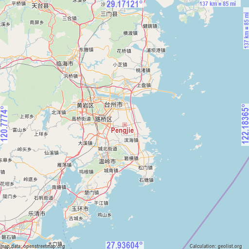
Pengjie GPS coordinates[2]
28° 33' 19.584" North, 121° 28' 49.872" East
| Map corner | latitude | longitude |
|---|---|---|
| Upper-left | 29.17121°, | 120.7774° |
| Center: | 28.55544°, | 121.48052° |
| Lower-right: | 27.93604°, | 122.18365° |
| Map W x H: | 137.3×137.3 km | = 85.3×85.3mi |
| max Lat: | 53.31946° ⇑69.2% North |
| Pengjie: | 28.55544° |
| min Lat: | ⇓30.8% South 18.22056° |
| min Long | Pengjie | max Long |
| 75.07348° | 121.48052° | 134.28917° |
| W 89.9%⇐ | ⇒10.1% E |
Elevation
Elevation of Pengjie is 7 m = 23 ft, and this is 477.8 m = 1568 ft below average elevation for this country.
| Max E: |
5622 m = 18445 ft | 94.3% |
| Avg. | 484.8 m = 1591 ft | |
| Pengjie | 7 m = 23 ft | |
Min E: |
-3 m = -10 ft | 5.7% |
See also: China elevation on elevation.city.
Geographical zone
Pengjie is located in North temperate zone (between Tropic of Cancer and the Arctic Circle). Distance of this Northern Tropic circle is 569.1 km =353.6 mi to South.| Distance of | km | miles | from Pengjie |
|---|---|---|---|
| North Pole | 6832 | 4245.2 | to North |
| Arctic Circle | 4226.1 | 2626 | to North |
| Tropic Cancer | 569.1 | 353.6 | to South |
| Equator | 3175.1 | 1972.9 | to South |


Nearby cities:
15 places around Pengjie: (largest is in red/bold)
• Baiyun
15.5 km =9.6 mi,  331°
331°
• Fengjiang
10.6 km =6.6 mi,  260°
260°
• Haimen
15 km =9.3 mi,  338°
338°
• Hengjie
5 km =3.1 mi,  239°
239°
• Hongjia
9.3 km =5.8 mi,  314°
314°
• Jiaojiang
15.9 km =9.9 mi,  357°
357°
• Lubei
11.3 km =7 mi,  287°
287°
• Luqiao
10.7 km =6.6 mi,  284°
284°
• Sanjia
6.5 km =4 mi,  353°
353°
• Taizhou
12.8 km =8 mi, 338°
• Tongyu
15.2 km =9.4 mi, 285°
• Xiachen
4.8 km =3 mi,  321°
321°
• Xinhe
8.7 km =5.4 mi,  199°
199°
• Xinqiao
7.7 km =4.8 mi, 240°
• Zeguo
12.7 km =7.9 mi,  247°
247°
Sources, notices
• [Note1] Compared only with cities in China existing in our database
• [Src1] Map data: © OpenStreetMap contributors (CC-BY-SA)
• [Src2] Other city data from geonames.org with taken over terms of usage.
• [Src3] Geographical zone / Annual Mean Temperature by Robert A. Rohde @ Wikipedia
