Luqiao geodata
Luqiao (Zhejiang) is a populated place; located in China in Asia/Shanghai (GMT+8) time zone. With population of 427,890 people, there are 145 cities with bigger population in this country. Compared to other cities in China, 69.1% of cities are located further ↑North; 89.5% of cities are located further ←West and 94.3% of cities have higher elevation than Luqiao. Note1


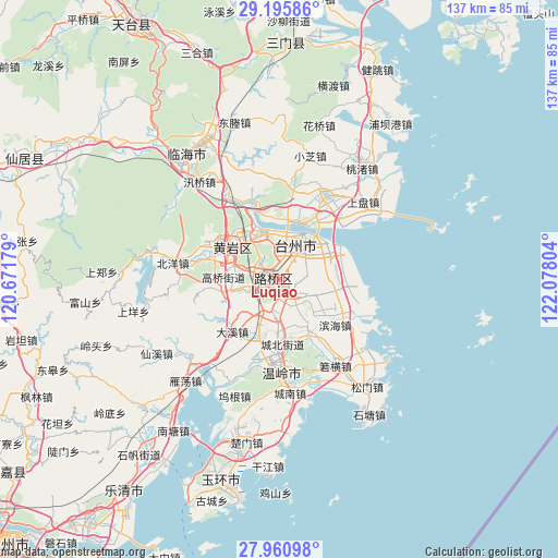
Luqiao GPS coordinates[2]
28° 34' 48.828" North, 121° 22' 29.676" East
| Map corner | latitude | longitude |
|---|---|---|
| Upper-left | 29.19586°, | 120.67179° |
| Center: | 28.58023°, | 121.37491° |
| Lower-right: | 27.96098°, | 122.07804° |
| Map W x H: | 137.3×137.3 km | = 85.3×85.3mi |
| max Lat: | 53.31946° ⇑69.1% North |
| Luqiao: | 28.58023° |
| min Lat: | ⇓30.9% South 18.22056° |
| min Long | Luqiao | max Long |
| 75.07348° | 121.37491° | 134.28917° |
| W 89.5%⇐ | ⇒10.5% E |
Elevation
Elevation of Luqiao is 7 m = 23 ft, and this is 477.8 m = 1568 ft below average elevation for this country.
| Max E: |
5622 m = 18445 ft | 94.3% |
| Avg. | 484.8 m = 1591 ft | |
| Luqiao | 7 m = 23 ft | |
Min E: |
-3 m = -10 ft | 5.7% |
See also: Luqiao elevation on elevation.city.
Geographical zone
Luqiao is located in North temperate zone (between Tropic of Cancer and the Arctic Circle). Distance of this Northern Tropic circle is 571.9 km =355.4 mi to South.| Distance of | km | miles | from Luqiao |
|---|---|---|---|
| North Pole | 6829.2 | 4243.5 | to North |
| Arctic Circle | 4223.4 | 2624.3 | to North |
| Tropic Cancer | 571.9 | 355.4 | to South |
| Equator | 3177.8 | 1974.6 | to South |


Nearby cities:
15 places around Luqiao: (largest is in red/bold)
• Baiyun
11.3 km =7 mi,  15°
15°
• Fengjiang
4.4 km =2.7 mi,  181°
181°
• Hengjie
8 km =5 mi,  131°
131°
• Hongjia
5.3 km =3.3 mi,  44°
44°
• Jiangkou
12.1 km =7.5 mi,  332°
332°
• Jiazhi
10.4 km =6.5 mi,  1°
1°
• Lubei
0.8 km =0.5 mi,  324°
324°
• Nancheng
11.4 km =7.1 mi,  287°
287°
• Pengjie
10.7 km =6.6 mi,  104°
104°
• Sanjia
10.3 km =6.4 mi,  68°
68°
• Taizhou
10.8 km =6.7 mi,  31°
31°
• Tongyu
4.5 km =2.8 mi, 286°
• Xiachen
7.4 km =4.6 mi,  82°
82°
• Xinqiao
7.5 km =4.7 mi,  151°
151°
• Zeguo
7.8 km =4.8 mi,  190°
190°
Sources, notices
• [Note1] Compared only with cities in China existing in our database
• [Src1] Map data: © OpenStreetMap contributors (CC-BY-SA)
• [Src2] Other city data from geonames.org with taken over terms of usage.
• [Src3] Geographical zone / Annual Mean Temperature by Robert A. Rohde @ Wikipedia
