Hongjia geodata
Hongjia (Zhejiang) is a seat of a fourth-order administrative division; located in China in Asia/Shanghai (GMT+8) time zone. In our database, there are 1268 cities with bigger population. Compared to other cities in China, 68.7% of cities are located further ↑North; 89.7% of cities are located further ←West and 86.9% of cities have higher elevation than Hongjia. Note1


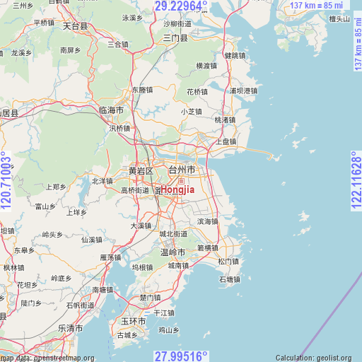
Hongjia GPS coordinates[2]
28° 36' 51.156" North, 121° 24' 47.34" East
| Map corner | latitude | longitude |
|---|---|---|
| Upper-left | 29.22964°, | 120.71003° |
| Center: | 28.61421°, | 121.41315° |
| Lower-right: | 27.99516°, | 122.11628° |
| Map W x H: | 137.3×137.3 km | = 85.3×85.3mi |
| max Lat: | 53.31946° ⇑68.7% North |
| Hongjia: | 28.61421° |
| min Lat: | ⇓31.3% South 18.22056° |
| min Long | Hongjia | max Long |
| 75.07348° | 121.41315° | 134.28917° |
| W 89.7%⇐ | ⇒10.3% E |
Elevation
Elevation of Hongjia is 13 m = 43 ft, and this is 471.8 m = 1548 ft below average elevation for this country.
| Max E: |
5622 m = 18445 ft | 86.9% |
| Avg. | 484.8 m = 1591 ft | |
| Hongjia | 13 m = 43 ft | |
Min E: |
-3 m = -10 ft | 13.1% |
See also: China elevation on elevation.city.
Geographical zone
Hongjia is located in North temperate zone (between Tropic of Cancer and the Arctic Circle). Distance of this Northern Tropic circle is 575.7 km =357.7 mi to South.| Distance of | km | miles | from Hongjia |
|---|---|---|---|
| North Pole | 6825.5 | 4241.2 | to North |
| Arctic Circle | 4219.6 | 2621.9 | to North |
| Tropic Cancer | 575.7 | 357.7 | to South |
| Equator | 3181.6 | 1977 | to South |


Nearby cities:
15 places around Hongjia: (largest is in red/bold)
• Baiyun
7.2 km =4.5 mi,  354°
354°
• Fengjiang
9.1 km =5.7 mi,  205°
205°
• Haimen
7.5 km =4.7 mi,  8°
8°
• Hengjie
9.3 km =5.8 mi,  166°
166°
• Jiaojiang
11.1 km =6.9 mi,  32°
32°
• Jiazhi
7.5 km =4.7 mi,  332°
332°
• Lubei
5.2 km =3.2 mi,  233°
233°
• Luqiao
5.3 km =3.3 mi,  224°
224°
• Pengjie
9.3 km =5.8 mi,  134°
134°
• Qiansuo
10 km =6.2 mi,  19°
19°
• Sanjia
5.9 km =3.7 mi,  90°
90°
• Taizhou
5.7 km =3.5 mi, 19°
• Tongyu
8.4 km =5.2 mi,  253°
253°
• Xiachen
4.5 km =2.8 mi, 127°
• Xinqiao
10.4 km =6.5 mi,  180°
180°
Sources, notices
• [Note1] Compared only with cities in China existing in our database
• [Src1] Map data: © OpenStreetMap contributors (CC-BY-SA)
• [Src2] Other city data from geonames.org with taken over terms of usage.
• [Src3] Geographical zone / Annual Mean Temperature by Robert A. Rohde @ Wikipedia
